The Foran Grade trail and Windy Point hike is a great choice for anyone who lives in the Calgary area and is eager for an outing that delivers great mountain views starting early in the season.
I wouldn’t do this hike in the summer when there are more interesting choices, but I’d come back again in the fall to catch the vibrant colours. The effort to reward ratio on this hike is high.
The Foran Grade trail hooks up with many other trails at well-signed intersections, so there are many days worth of hiking in the area.
This post includes some affiliate links. If you make a qualifying purchase through one of these links, I will receive a small percentage of the sale at no extra cost to you. Thank you very much for your support.

Foran Grade trail summary
Permit: You will need to purchase a Kananaskis Conservation Pass to hike the Foran Grade Trail. The pass is $15 for the day but $90 for a full year good for two vehicles at the same address.
Trailhead when highway is closed: The access to the well-signed trailhead is from the Sandy McNab Day-use Area in the Sheep River area of Kananaskis Country near Turner Valley is closed to cars from December 1 to May 14. Fortunately you can access the trail by walking the closed road for 1.5 km in each direction.
Limited parking: There isn’t a lot of parking at the trailhead once the highway is open – perhaps four of five vehicles at most.
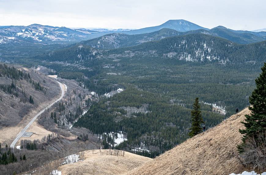
Highlights: The Foran Grade trail has excellent views of Sheep Valley and Windy Point.
Distance/elevation: If you just do the Foran Grade trail, the hike is 6.4 km as an out and back hike with 240 m or 787 feet elevation gain. Add in another 3 – 4 km if you have to hike the highway and hike up to Windy Point.
Time needed: Allow 2.5 – 4 hours to do the hike.
Level of difficulty: I’d call this an easy hike if you stick to the Foran Grade Trail. It’s moderate if you climb up to Windy Point.
Hiking option: You can also make it into a loop trail by descending the Windy Point Trail and hiking back to the trailhead via the Sheep Trail.
Trail conditions: Check the Alberta Parks trail report before you go.
Bears: Carry bear spray and make sure it’s quickly accessible.


Foran Grade Trail and Windy Point details
All told the Foran Grade Trail hike is about 10 km return, depending on exactly what route you follow – and that includes 3 km back and forth from the winter gate.
It’s 3 km shorter come May 15th when you can drive to the trailhead. Expect to climb about 305 metres in total. Allow 2.5 – 4 hours.

Foran Grade Trail – Windy Point hike photos and description
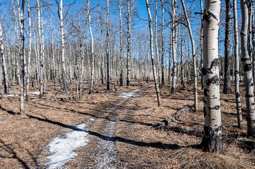
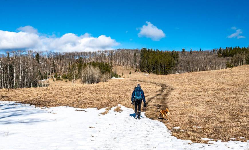
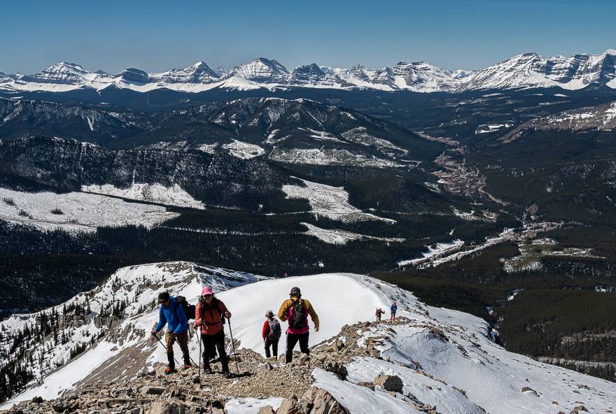
The first part of the hike was a gradual walk up through pretty meadows and open woods to a high point on the ridge line.
We didn’t see any cows on our hike, but they certainly left their evidence behind. There was some ice and mud – but we only needed microspikes for a few minutes on the descent to the trail intersection.
We hiked in a counter-clockwise direction to do the loop – rather than an out and back hike. At the 1.2 km point, you’ll reach a beautiful birch grove with some open views. Continue hiking to the end of the bench. Descend to reach an intersection at the 3.5 km point.
You can take the Windy Point Trail here to reach the highway – but this is where we went up to survive the view from Windy Point.
When you reach the highway you can continue walking back to your car on the road or cross the highway and pick up the trail that parallels the Sheep River back to your car.
In spring, it can be very muddy and the highway is probably the better option.


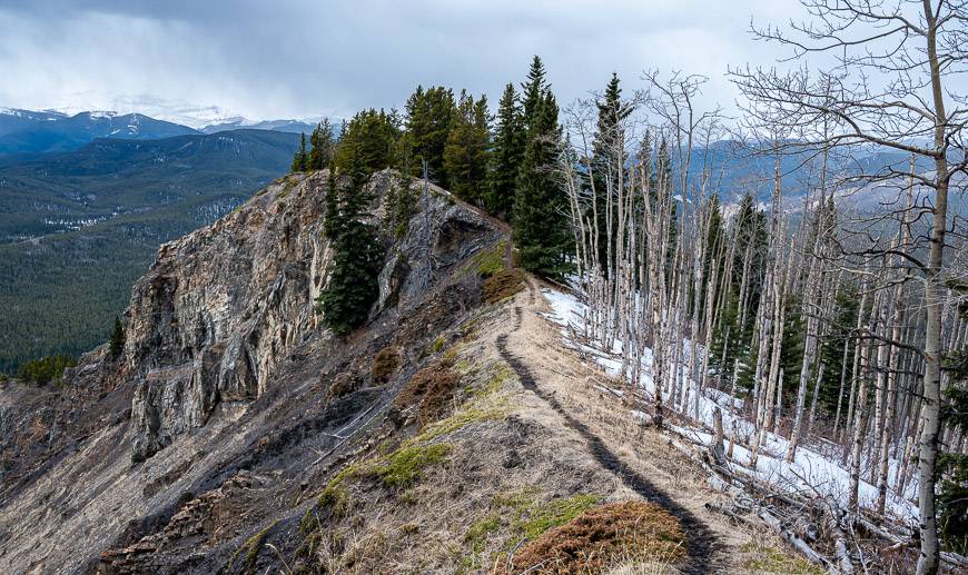
Windy Point
Reach a signed intersection after the descent from the Foran Grade trail. There is an option to follow the Windy Point Ridge Trail – but in early April, we found it hard to follow.
Instead, we hiked steeply off trail, contouring up to reach the ridge line. When we got there, we went right at first to see where the trail went.
After reaching a high point, we retraced our steps and settled in the lee of some trees to enjoy lunch with a view. We could see the office towers of downtown Calgary from our perch.
Then we went the other way to check out Windy Point itself – a place with great mountain views including Banded Peak and Threepoint Mountain.


The descent from Windy Point back to the road
It’s a very steep descent down to the Foran Grade trail from Windy Point. We picked our way down carefully and I for one was happy to have a hiking pole.
Once we got into the woods, we just headed in the general direction of the trail we’d seen from above and followed it to the road.
There is the option to take a trail on the far side of the highway – above the river back to the parking lot. This would normally be a good option but it was very muddy, so we stuck to the highway and walked back in about 20 minutes.


A few things that come in handy on the hike
Hiking poles are super helpful if you’re hiking early in the season with snow on the ground. They also give you more stability on the descent from Windy Point.
Pick up a map for the area – Gem Trek Bragg Creek & Sheep Valley.
A blow up seat cushion will make for a more comfortable lunch time spot, especially if the ground is wet.
Don’t forget some energy bars and perhaps a chocolate bar or two. I highly recommend Whittaker’s Peanut Slab.
Bighorn sheep reside in the Sheep River Valley year round
Bighorn sheep live in the Sheep River Valley on a year-round basis. In fact, the road is closed to protect their winter range.
According to a researcher we met at the winter gate, there are approximately 100 bighorn sheep living in the area.

Foran Grade Trail – Windy Point trailhead location
Drive to Turner Valley – called Diamond Valley as of 2023. At the four-way intersection by the gas station, head west on Highway 546.
Take it for about 21 km to reach the winter gates by the Sandy McNab Campground. If the gates are open (which they will be from May 15 – November 30) continue for another 1.5 km to reach the trailhead and small parking area.
Further reading on hiking and biking in Kananaskis Country
The Sheep River Road is ideal for biking, especially when it’s closed to traffic. In April there was only a minor amount of snow on the road that could be easily avoided.
If you’re into biking, you might also enjoy the ride up Highwood Pass from the Longview area before June 15th – when it opens to cars.
The Raspberry Ridge hike is an excellent early season hike as is the Mount Burke hike.
Grass Pass is another hike that isn’t on the radar of many people.
Click on the photo to bookmark to your Pinterest boards.
