Cory Pass Hike, Banff National Park
It took me over a decade of living in Calgary for me to do the Cory Pass hike. Don’t leave it that long. The views once you’ve climbed about 20 minutes up from the turnoff to Cory Pass are great – and they continue to enchant for several hours.
This is a difficult hike and not one for those who hate a lot of elevation gain (about 900 m over just 4.5 km) or dislike airy trails. There is a long section of hiking across open slopes with steep gullies that you must navigate to reach Cory Pass – a great place to stop for lunch and take in the mountain landscape.
The views from Cory Pass are like no other I’ve seen in Banff National Park – dramatic, austere, magnificent, and reminiscent of a fabulous hiking trip to Zanskar in northern India. The descent from Cory Pass wasn’t as gnarly as I expected it to be. There was plenty of scree, but after losing about 100 m of elevation, the grade moderated and some of the scree was the good kind, where you could plunge step and make good time.
When you get to the trail in the trees, you’ll probably just want to be back at the trailhead. The last 4 km or so of the Cory Pass hike isn’t as interesting, but at least it’s easy.
Some people do an out and back on the Cory Pass trail, but I love a good loop hike and found it easy to find the trail on the backside of Edith Mountain.
This post includes some affiliate links. If you make a qualifying purchase through one of these links, I will receive a small percentage of the sale at no extra cost to you. Thank you very much for your support.
Would you like to save this?
Cory Pass hike summary
Distance: Approximately 11.6 km (7.2 miles) return as an out and back hike or 13.0 km (8.1 miles) as a loop hike around Mt. Edith
Elevation: 900 m (2,953 feet) to Cory Pass, 1,000 m (3,281 feet) on the circuit around Mt. Edith
Level of difficulty: Hard
Time needed: 4.5 – 6 hours.
Best time to do the Cory Pass hike: Any time after the snow has melted, so late June or early July – until the snow flies again. You do not want to be on the steep narrow trails with snow unless you have considerable experience with an ice axe and self arrest!
Backcountry campsites: None on the hike.
Dogs permitted: Yes, but this hike is exposed and there isn’t any water except at the very start and end – and some dogs might have a tough time on the scree.
Permits: You will need a National Parks pass to do anything in Banff National Park.
Map: Gem Trek Banff and Mt. Assiniboine
Cory Pass hike trailhead location
To get to the Cory Pass trail take the exit off the Trans-Canada Highway, onto Highway 1A – west of Banff, also called the Bow Valley Parkway. Drive north for half a kilometre and turn right onto an access road that takes you to the Fireside Picnic Area. It’s a kilometre up the road to reach the parking lot.
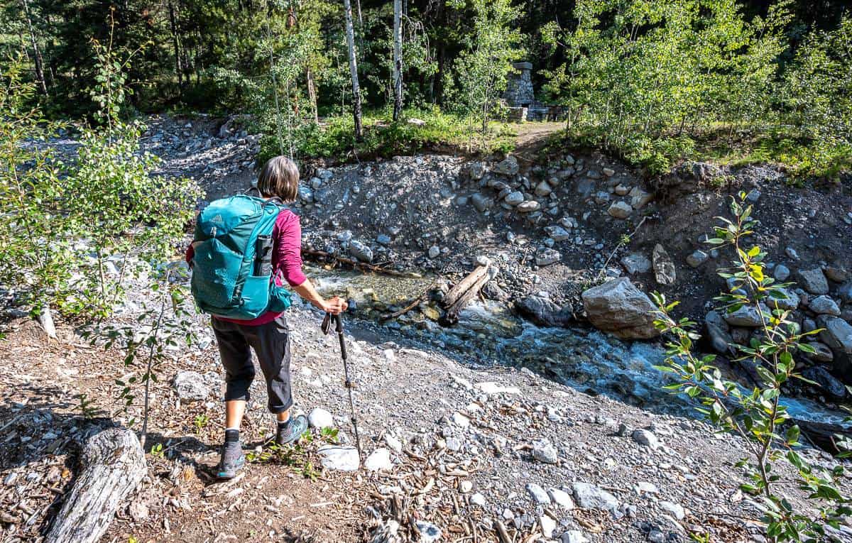
The formal Cory Pass trail starts on the far side of the creek. When I did it there wasn’t a bridge in place so be prepared to rock hop. You know you’re in the right place when you see the remains of a rock fireplace and picnic tables.
Best time to do the Cory Pass hike
The Cory Pass hike is best done after the snow has melted, so sometime beginning in early July until the snow starts to fly late in September. Before you go check the Banff National Park trail conditions. If there is snow, crossing the open slopes on the way to Cory Pass could be dangerous. One slip, and you’d have a problem.
I’d also recommend checking the weather forecast before you go, just in case there are thunderstorms in the offing.
What should you take on the hike to Cory Pass?
Don’t forget to pack the hiking essentials including sunscreen, at least 2 litres of water, and layers of warm clothing as it can be cold at Cory Pass. I think hiking poles come in handy on this hike, both going up and down.
We saw one pile of old bear scat on the woodsy section of the trail and that’s it. I’d recommend carrying bear spray that’s easy to access just in case. I keep mine in a bear spray holster – so I don’t set it off accidentally – which can happen more easily than you might think.
Cory Pass hike description
I had expected more route-finding issues on the hike to Cory Pass and Edith Pass. It’s quite straightforward as long as you stay high near the end of the scree section on the descent, but be prepared for a workout after the first kilometre.
To start the hike to Cory Pass, cross the stream via rocks and logs to the Fireside Picnic Area as there is no bridge in place right now. (There is a big bridge on land that looks like it is ready to be moved). Hike 1.1 km through a coniferous forest, to reach a junction. Turn left to head to Cory Pass. If you do the loop hike, you’ll end up back here near the end of the hike.


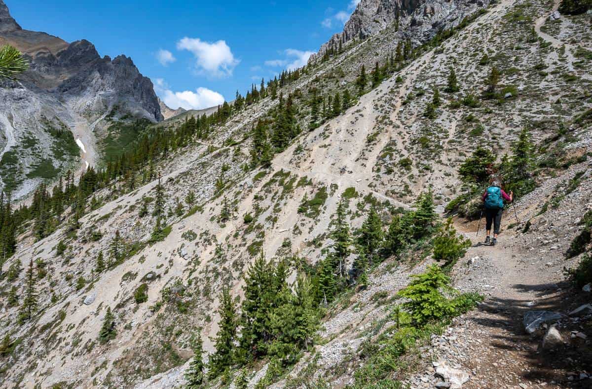
Start climbing up an open slope on a steep, can’t-catch-your-breath grade. At 1.7 km reach the Cory Knoll Viewpoint. Enjoy views in either direction as shown below.


Continue hiking up through the forest to a ridge offering the first view of Cory Pass off in the distance. To the right in the photo below is 2,553-m high Mt. Edith and to the left is 2,801-m high Mt. Cory.
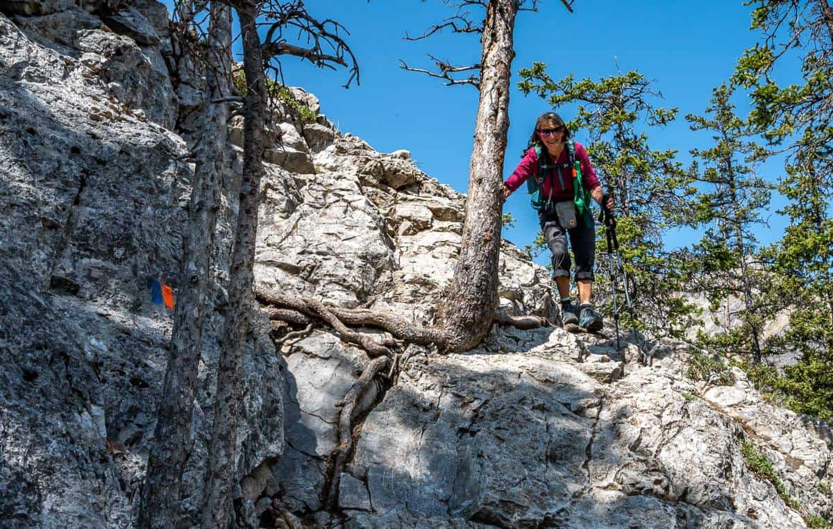
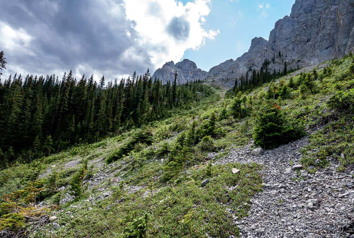
The Cory Pass trail follows the ridgeline at a modest grade save for one steep section. At the top of the forested ridge at the 2.4 km mark, there’s a cliff-band that requires a steep, but not difficult down climb. It’s marked by paint on the rocks and there is one hiker sign part way down. From the base of the cliff stay on the obvious but narrow trail as it gradually climbs the open southwest slope of Mt. Edith towards Cory Pass.
Fun fact: Mount Edith, pictured on the right below, is named for Edith Orde, assistant to Lady Agnes MacDonald, the wife of Sir John A. MacDonald.


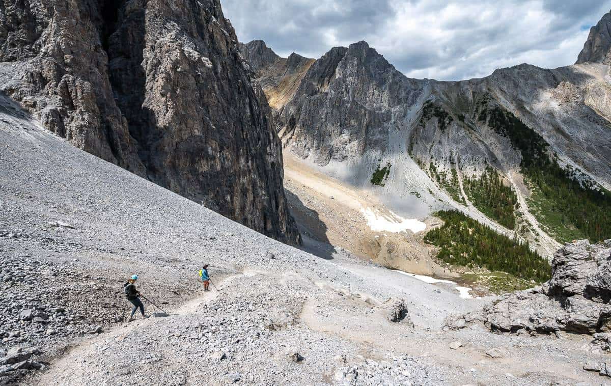
Some hikers might find the trail across the open slopes too airy for their liking. I didn’t like crossing the rock gullies or the avalanche chutes, but they were short. The rock gullies can be problematic if there is snow. I never like to linger in these areas in case of rockfall.
Top out at Cory Pass at 5.5 km and an elevation of 2,360 m. This is a great place to linger over lunch, but don’t forget some warm clothes as the wind blows up here on a regular basis.


The descent from Cory Pass
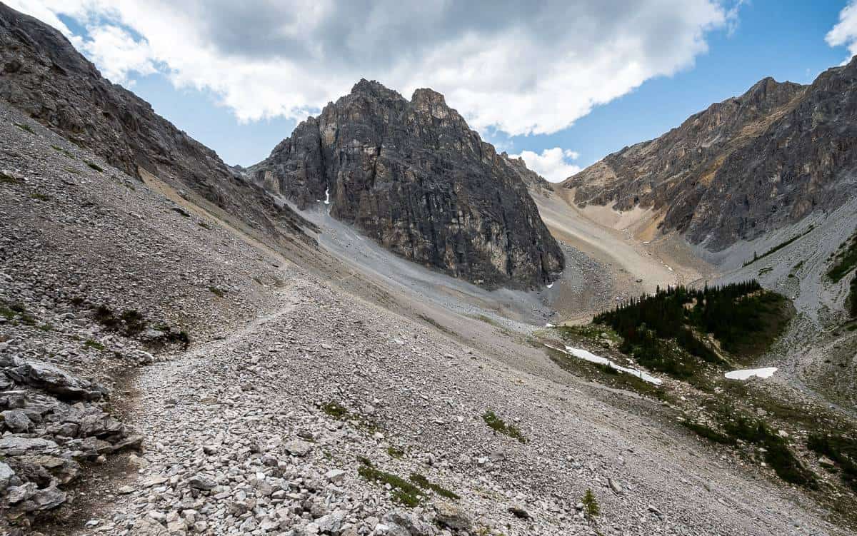
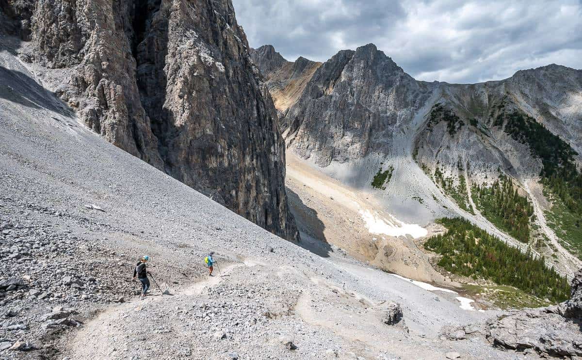
Looking down from Cory Pass I saw nothing but scree. It looks a bit dodgy at the top, but if you take your time, you’ll be through the worst section of it in about 10 minutes. Then the grade moderated, and I found the rest of the scree was easy to hike through.
The trail curves through what is called the Gargoyle Valley, though it looked to me that the only gargoyle-like rocks were at Cory Pass. You’ll have to be the judge.
Don’t forget to look back at Cory Pass as the mountain scene is spectacular. I’d also suggest slowing down and savouring this part of the Cory Pass hike, especially near Mount Louis, a fang of grey limestone considered to be one of the most difficult rock climbs in Banff National Park. Although we didn’t see any climbers, we did notice a lot of climber trails in the area.
Continue through the scree and rocks to reach an open area. Stay high, crossing a boulder field, while looking for cairns. In the trees sharp-eyed people will see an orange sign. When you get closer, you’ll recognize it as a hiker – which means you’re on the right track.


Into the woods to complete the Cory Pass hike
Gain about 100 m again once you’re in the trees, and then descend to reach 1,950-metre-high Edith Pass. Go right and descend through the forest, initially steeply and then the grade moderates. (If you went left, you’d end up at Forty Mile Creek).
After a further 2.9 km of not so interesting hiking, reach the junction where you started the climb to Cory Pass. You’re only 15 – 20 minutes from the parking lot now and back in familiar territory.


Places to stay in Banff National Park
Some of my favourite hotels in Banff include the Moose Hotel – great location, Buffalo Mountain Lodge – excellent restaurant and wood-burning fireplaces plus a huge outdoor hot tub and the Fairmont Banff Springs Hotel when I’m looking to splurge.
One of the best family-friendly options is the Canalta Lodge – with bunk beds in some rooms. And the Dorothy Motel is Banff’s first boutique motel.
Map of our Cory Pass hike

Further reading on great hikes in Banff National Park
- Sawback Trail Hike: Johnston Creek to Baker Lake
- A Hike to Bourgeau Lake and Harvey Pass
- A Hike Into Sunshine Meadows, Banff National Park
- North Molar Pass and Fish Lakes Multi-Day Hike
- Sunset Pass & Sunset Lookout Hike – Icefields Parkway
Click on the photo to bookmark to your Pinterest boards.