Elk Lakes Petain Falls Hike, British Columbia
For a magnificent but long day hike or an outstanding 3 – 4-day backpacking trip that offers waterfalls, gorgeous mountain lakes, wildflowers, glaciers, and the enchanting Petain Basin, visit Elk Lakes Provincial Park in British Columbia. Specifically do the hike to the Elk Lakes and Petain Falls.
If you’ve got the time and the stamina continue up the very steep trail to explore the spectacular Petain Basin after the snow has melted in late July. It’s possible to wild camp up here – and if you do, you’ll be rewarded with what author Craig Copeland calls an “alpine Eden with Petain Glacier just one of the enthralling sights.”
We did a three-day version of the Elk Lakes Petain Falls hike starting from the Alberta side in Peter Lougheed Provincial Park over a Labour Day weekend. Interestingly, most people hike into the Lower Elk Lake Campground from the BC side – accessed via logging roads from Sparwood.
If you come in from the BC side, you only have to hike one km to reach the Lower Elk Lake Campground.
It’s an easy hike with carts provided so you can really kit out your camp and enjoy a semi-luxurious experience. From Peter Lougheed Provincial Park, where we started, it’s a 10 km hike to reach the Lower Elk Lake Campground, so our only luxury was a bottle of wine.
This post includes some affiliate links. If you make a purchase via one of these links, I will receive a small commission at no extra cost to you. Thank you very much for your support.

Would you like to save this?
Elk Lake Petain Falls hike summary
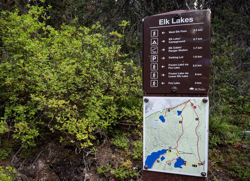
Starting point: You can do the hike to Elk Lakes Provincial Park from both Peter Lougheed Provincial Park in Alberta and from logging roads out of Sparwood, BC.
Permits: If you start in Alberta, you will need a Kananaskis Conservation Pass. They are $15 per vehicle per day or $90 per year good for two vehicles at the same address.
Distance from the Alberta trailhead: To Upper Elk Lake it’s 16.4 km (10.2 miles) return with a 185 m (607 feet) elevation gain and 140 m (459 feet) loss. It’s 1.2 km (0.8 mi) one way from the Upper Elk Lake trail to the Lower Elk Lake campground.
Distance to Petain Falls: From the northeast end of Upper Elk Lake, it’s a 4.2 km hike to reach Petain Falls.
Distance to Petain Basin from the Alberta side: It’s a 29.4 km (13.3 miles) return hike with 704 m (2,310 feet) of elevation gain.
Distance Petain Falls to Petain Basin: 2.3 km (1.4 miles) one way but there’s a stiff climb in there of 457 m (1,500 feet).
Time needed: Allow 6 hours to hike to Upper Elk Lakes return from Alberta but to hike to Petain Basin properly, do an overnight trip.
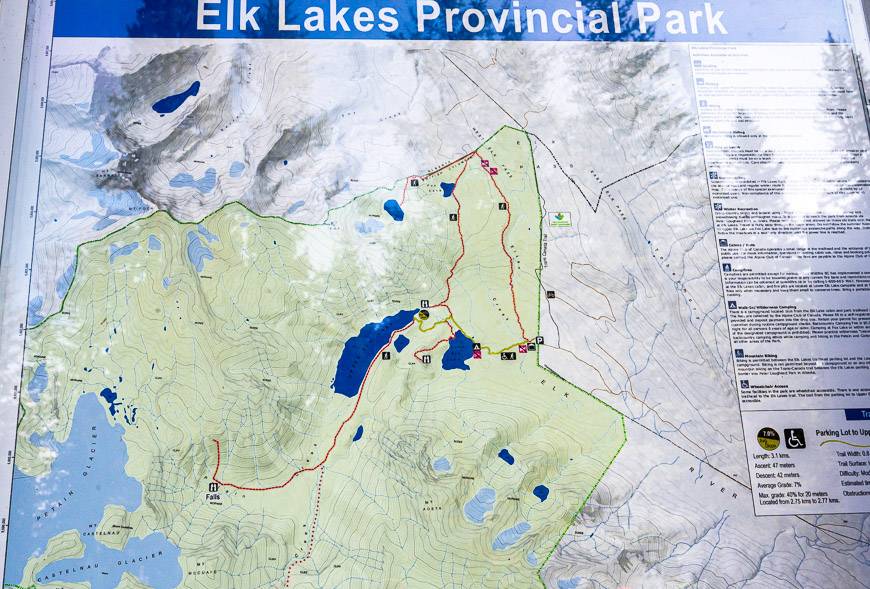
Map: Gem Trek Kananaskis Lakes. It really helps put the trails and campground into perspective.
Bears: You’ll be hiking in grizzly bear country so keep the bear spray close at hand.
Dogs: Permitted on a leash.
Don’t forget: Always carry the hiking essentials and let someone know where you’re going and when you’re due back.

Elk Lakes Petain Falls hike options
There is lots of signage no matter what province you start in, so you won’t get lost. But I did find the mileage on the signs differs from some guide books. Keep that in mind and use my numbers as an approximation.
To complicate matters further, there are two trails that head south from West Elk Pass on the BC-Alberta border to the Elk Lakes trailhead.
We took the western-most trail that leads directly to Upper Elk Lake and not the trail that parallels Elkan Creek. That is reportedly a shorter route in and out to the Lower Elk Lake campground.
Alberta options for day hikes in Elk Lakes Provincial Park
If you’re coming in from Alberta, you could easily hike out and back to Upper Elk Lake in a day – a distance of 16.4 km return with a 185 m elevation gain and 140 m loss.
That would take you about 6 hours. To continue to Petain Falls and return to the parking lot in a day you’ll need to knock off approximately 25 km – rather a long day hike, even without a lot of elevation gain. Petain Basin really requires an overnight stay.
BC options for day hikes to Elk Lakes and Petain Falls
If you’re coming in from Sparwood, you could make it to Petain Falls and back in a day as it’s only 16.6 km without a lot of elevation gain. In fact, you could even knock off Petain Basin if you’re a quick, strong hiker.
Its another 2.3 km one way beyond Petain Falls to Petain Basin – but there’s a stiff climb in there of 457 m (1,500 feet). That would put you at 21.2 km for the day, but it won’t allow much time for exploring.
What we did in Elk Lakes Provincial Park
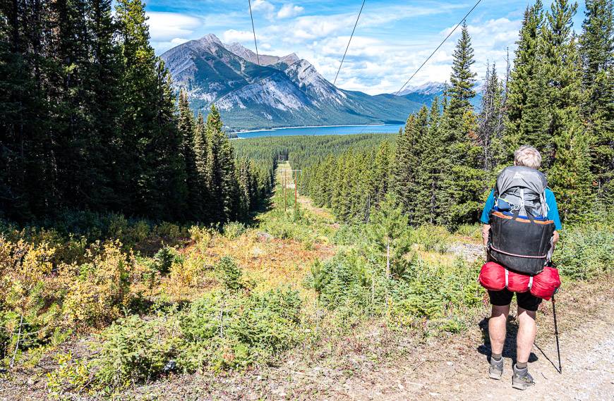
John and I and our son Matt started at the Elk Pass trailhead in Peter Lougheed Provincial Park on a Friday afternoon. We hiked into Lower Elk Lake and camped for the night.
On the Saturday we did and out and back hike to Upper Elk Lake, Petain Falls, and Petain Basin that took us most of the day at a leisurely pace. However, we didn’t have enough time to properly explore Petain Basin so that’s another trip.
We spent a second night at Lower Elk Lake campground and hiked back to the car on Sunday in about three hours, passing the freshest bear scat I’ve ever seen just a few hundred metres from the car.

The route into Lower Elk Lake Campground from Alberta
The trail starts at the Elk Pass parking lot in Peter Lougheed Provincial Park on a gated gravel road. It follows Powerline Road to the first bridge crossing of Fox Creek at the 2.0 km mark.
After the bridge take the right fork, looking for signs like the one pictured below. Continue hiking past a picnic table and ultimately 100 m past the Blueberry Hill Trail turnoff. Look for the next hiker symbol and follow the arrows to a narrower trail which leads to West Elk Pass on the Alberta – British Columbia provincial boundary.
This section of the hike was far better signed than I ever expected.

The BC – Alberta border to Lower Elk Lake campground
At the provincial border there is a big map and signage for two trails. We followed the trail towards Fox Lake just 0.7 km away. To get there, traverse lovely sections of boardwalk. You’ll also pass a turnoff to Frozen Lake. It’s a 2 km one-way hike to the lake from the provincial boundary.
If you’ve come in from Sparwood and are spending a few nights at the Lower Elk Lake campground, the hike to both Fox Lake and Frozen Lake would be a good day outing.
It’s 3.5 km from Fox Lake to Lower Elk Lake campground. The first 15 minutes past Fox Lake is mostly on level trail. Then it begins a descent with lots of viewless hiking among scrawny trees.
But, there is one particularly pretty section, about 10-15 minutes into the descent where you can glimpse Lower Elk Lake and the surrounding mountains of the Upper Elk Valley.
When you reach the signed T-junction, head left and follow the trail 1 km to the Lower Elk Lake campground. You’ll have to return to this junction to continue to do the Elk Lakes Petain Falls hike and then onto the Petain Basin the following day.


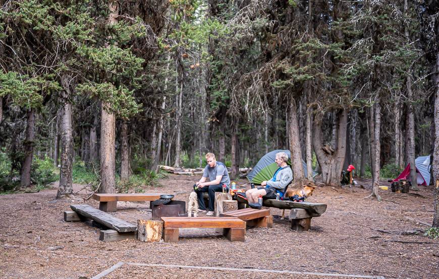
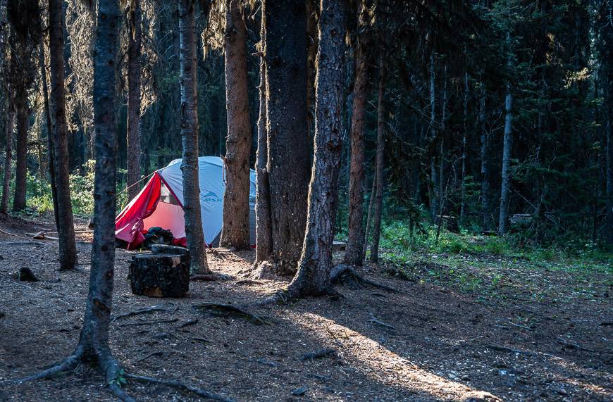
Camping at Lower Elk Lake
It was a treat to camp at Lower Elk Lake. You can’t make a reservation because all of the campsites are on a first come, first served basis. (I didn’t count how many campsites there are, but I’d guess about 20.)
That’s a real bonus when you only want to camp when you know the weather is going to be good.
We changed our plans over the Labour Day weekend, leaving on a Friday instead of a Saturday to get the good weather.
With a Friday afternoon arrival, we also had our pick of the campsites whereas by Saturday night, people were camping wherever they could find a flat spot.
The campsite is equipped with bear-proof lockers, pit toilets, fire rings, benches, and tent pads. At the lake there is a small kiosk with self-registration envelopes. We paid $5/night per tent pad and brought cash. You keep your stub as proof of payment.
All the campsites are just a short walk from Lower Elk Lake. Along the lake there are a couple of benches that are perfect for enjoying the view.

Elk Lakes Petain Falls Hike (and Petain Basin if you’re up for it)
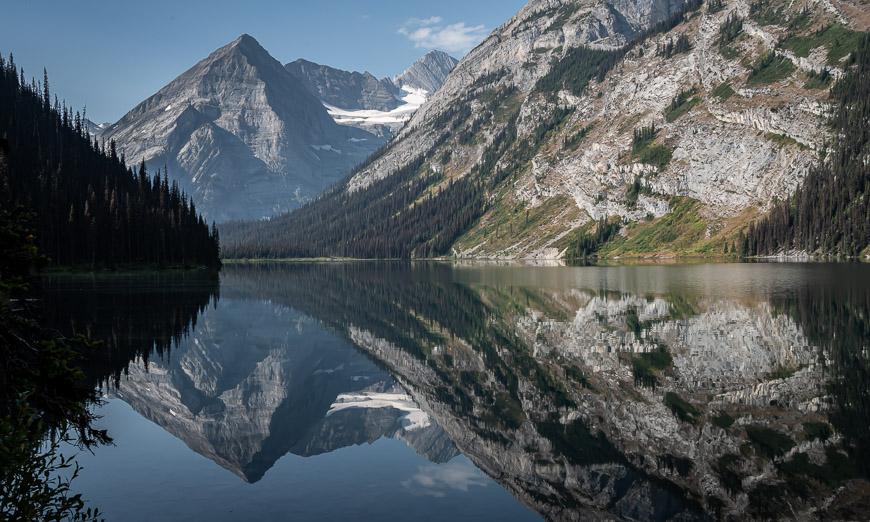
From the Lower Elk Lake campground retrace your steps to reach the signed T-junction 1 km away. Stay on the well-defined trail to stunning Upper Elk Lake, 1.4 km away.
Along the way you’ll pass a turnoff to the 1.2 km long Viewpoint Trail. It climbs 122 m and offers an exceptional view of Lower Elk Lake.
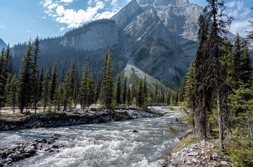
The trail to Petain Falls skirts Upper Elk Lake for most of its length. At the south end of the lake cross gravel beds – that can get flooded when the water is high, thereby making route-finding a tad challenging. Look for flagging tape in the trees and the occasional cairn to keep you on course.
Stay right at the sign pointing to Coral Pass. A few minutes later cross a bridge over Nivella Creek. Continue hiking upstream on the east bank of Petain Creek to reach a trail intersection. Go left to take the spur trail to Petain Falls.
It’s perhaps 10 minutes at most to the falls and a worthy side trip. In summer, the meadows on route to the falls are filled with wildflowers.


The hike to Petain Basin
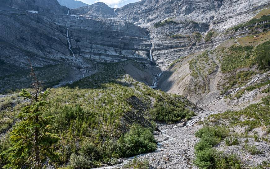
To continue to Petain Basin head right at the intersection with Petain Falls and start climbing – for the next 3 km.
The trail is obvious for most of its length and it’s not very busy. Only a small fraction of hikers that visit Petain Falls continue up Petain Basin.

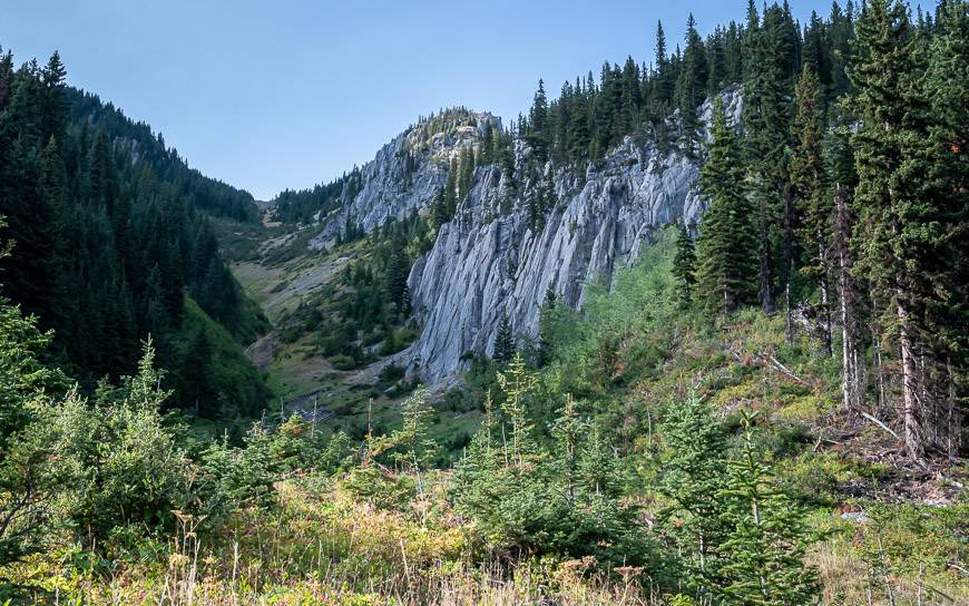
When you reach the bottom of a rocky gorge head for the left side where you can see the trail. This is a good place to cool off and refill water bottles as there is a dribble of water coming out of some rocks.
From this point the route markedly steepens and heads up through some massive trees. When the trail finally leaves the trees, you end up in a rocky chute. I thought at first, we’d have to climb to the top of it but you don’t. Ascend it for 5-10 minutes, keeping an eye out for a well-defined trail on the left.
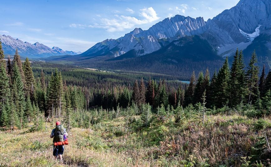
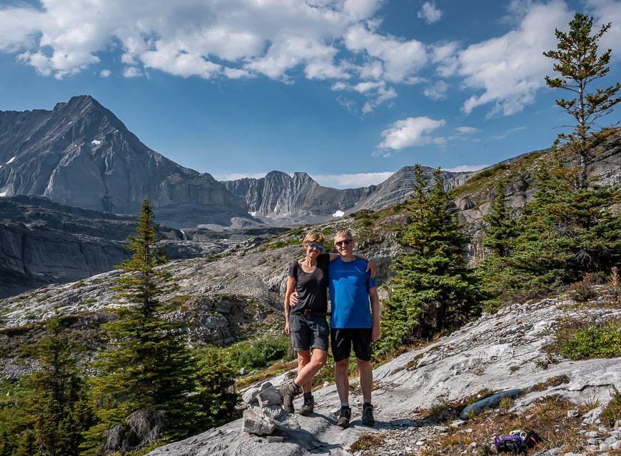
Once out of the chute, you’re onto grassier slopes and the walking gets much easier. Enjoy the wildflowers as you traverse several rocky knolls and one final lip to arrive in the Petain Basin.
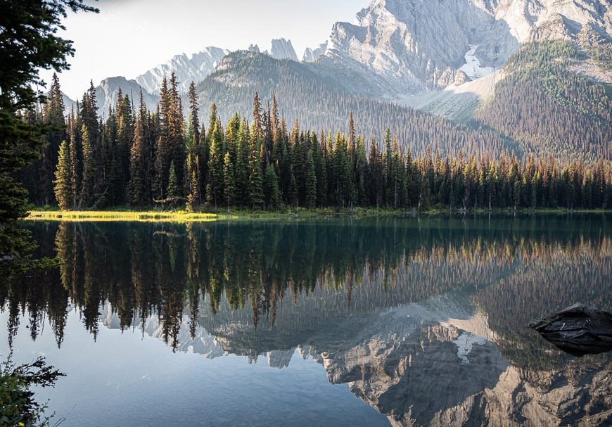
If you have the time, there’s a lot to explore. Hike across the grass and rock slabs for ever improving views, especially of Petain Glacier. We ran out of time but would consider camping here so we could at least contemplate summiting 3,180 m Mt. Foch.
Retrace your steps to the campground – or one of the wild camping spots you’ve chosen along Petain Creek. Remember to follow Leave No Trace principles.

The Elk Lakes hike return to the Peter Lougheed trailhead
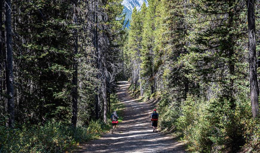
On our last day we enjoyed an easy three-hour hike back to the car. The following photos give you an idea of what you’ll see once you’re back in Peter Lougheed Provincial Park.
Getting to the Elk Lakes Petain Falls trailhead in BC
Located in southeastern BC, Elk Lakes Provincial Park is roughly 104 km due north of Sparwood. Take Highway 43 heading north out of Sparwood and follow it for 35 km to reach Elkford.
From there continue for about 47 km on the gravel road on the west side of Elk River. When the road crosses the Elk River it joins the Kananaskis Power Line Road. From the crossing of the river to the Elk Lakes trailhead it is a distance of 21.9 km.
Allow the better part of two hours from Sparwood to reach the parking lot. You’ll be on logging roads so pay close attention and always be on the lookout for the big trucks.
Getting to the Elk Lakes Petain Falls trailhead in Alberta
Its just under a two-hour drive from Calgary to get to the Elk Pass trailhead parking lot in Peter Lougheed Provincial Park. Take the Trans-Canada to the intersection with Highway 40 South. Drive 50 km.
Turn southwest onto Kananaskis Lakes Trail. Continue for another 12 km to reach the signed parking lot on the left-hand side of the road.
We didn’t find any signage about overnight parking, so we just left the car at the trailhead with nothing visible in sight to steal.
What to take on the Elk Lakes Petain Falls hiking/camping trip
If you are planning to hike to Petain Basin, I think you’ll find collapsible hiking poles come in handy, especially on the descent.
To add a little comfort to your camping experience, I’d recommend a camp pillow, a portable French press so you can enjoy a few cups of coffee around the campfire, an easy, lightweight water purification system and a portable camp chair because why not be comfortable on a backpacking trip?
More backpacking trips I’d recommend
- 10 Beginner Backpacking Trips in the Canadian Rockies
- The Sunset Pass & Sunset Lookout Hike on the Icefields Parkway
- The Glacier Lake Hike in Banff National Park
- The Hike to Three Isle Lake Hike & South Kananaskis Pass
- Sawback Trail Hike: Johnston Creek to Baker Lake
Click on the photo to bookmark to your Pinterest boards.