This post from writer Sylvia Dekker takes you on a couple of standout hikes in Merritt, British Columbia – a community you might have stopped in for gas or coffee while driving the Coquihalla Highway between Vancouver and Kamloops or on the way to the Okanagan via Kelowna. If you’re like me, you probably didn’t know about the great hiking and backpacking opportunities in the Merritt area. Now you will!
The area surrounding the Merritt, British Columbia area is a wilderness of roads, rolling hills, peaks and unfrequented trails—the perfect destination for quiet, wild, beautiful outdoor adventures.
During the one and a half years we lived near Merritt we explored all directions deep into the wilderness. Days before a day off my husband would scour the map looking for some remote hike and barely-there trails. We’d set off with stuffed backpacks and return with full lungs of fresh air and fully sore legs.
Of all the hikes, bush-wacks, FSR journeys and hunts we did, two hikes in Merritt consistently pop up in my mind when people ask about nice hikes in the area, or if I’m daydreaming.

This post includes some affiliate links. If you make a purchase via one of these links, I will receive a small commission at no extra cost to you. Thank you very much for your support.
Hikes in Merritt, British Columbia – Mt Hewitt Bostock
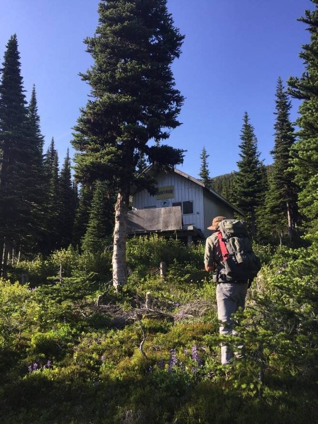
Mt Hewitt Bostock was a very peaceful, stunning experience. The area is popular in the winter for snowmobilers, evidenced by the trees cut off on the trail at my height. The trail starts in the trees and winds into the mushy alpine bright with wildflowers—lupine, paintbrush and arnica.
A snowmobiler’s cabin, charmingly named the Honeymoon Cabin, is nestled in the trees along the trail and is open to travelers to rest and warm up in.

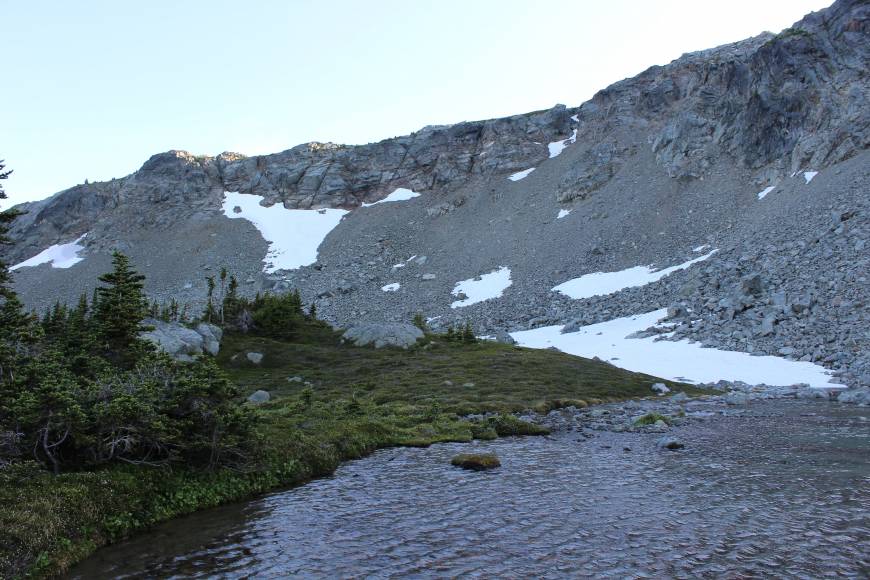
Beyond the cabin we lost the trail but luckily had a map and knew what ridge we were heading towards. We picked our way through the thick heather and squishy moss growing beside little bubbling creeks, heading up towards the saddle.
By the time we made it to a little lake nestled under the towering ridge, I was ready to stop for the night.


We set up camp and swam away the sweat, the freezing water soothing the bug bites.
The sound of tumbling rocks drew our eyes up to the ridge where a group of mountain goats met our gaze with equal curiosity. We watched them watching us until the mosquitoes drove us into our tent.
Our woeful hound dog begged to join us in his non-negotiable way, pushing past me as I crawled in and wriggling gleefully all over before settling in a tiny ball beside my husband, laying his head on his chest. We let him stay.
The next morning we made our way to the ridge for breakfast, absorbing the rugged views and the oatmeal while enjoying the breeze carrying away the whining mosquitoes.
We couldn’t stay long—a looming night shift cut our lofty relaxation short—and unsure of where the trail was we headed back down the way we came. Back at the cabin we found where we’d gone wrong: the trail continues behind the cabin, not past it like we’d assumed.
Keep an eye out for high markers and trees cut at about eye level to give clues to where the trail is if it becomes obscure.

There is not much information available online about this trail and access, but the solitude, pure nature and views were worth hiking a long ways down the wrong forest service road, at least to start.
Finding the Mt Hewitt Bostock Trail
According to the Backroad Mapbook’s Outdoor Recreation map of the Chilliwack and Merritt areas, the trail is named after the cabin—the Honeymoon Trail.
The snowmobile trailhead is about 33 kilometres down the Prospect Creek FSR, which branches off of Sunshine Valley Road, left off of Highway 8. A 4×4 vehicle may be able to make it a ways down the wide snowmobile trail, but a section of the wider trail will probably need to be hiked to reach the actual hiking trailhead.

The Stoyoma Mountain area near Merritt British Columbia
If you take a left at the fork on Prospect Creek onto the Petit Creek FSR, you will find yourself in the Stoyoma Mountain area.
Cabin Lake is well known to Merritt residents but the road is terrible, so be prepared to hike or bike it if you don’t have a 4×4 with good clearance. If you do make it to the lake, there are multiple great camping spots. After jolting down the rutty road one evening, we spent the night in sleeping bags under a tarp shelter, our hound dog curled between our heads, and had the entire campsite to ourselves.


Stoyoma Wilderness hike – one of the top hikes in Merritt, BC
The next morning we headed off for a day exploring the Stoyoma wilderness. There is an actual trail you can follow into the alpine from the lake and it is much more obvious than the Mt Hewitt Bostock trail. It will guide you on the right side of the lake to the far end through forest and meadows and into the alpine.
Instead of following that trail, we approached the hike backwards with the intent of glassing the valleys for alpine deer. We strode out of camp and straight up, picking our own trail up and across the ridges. A mama bear and two rowdy cubs browsed a hillside across from our ridge perch, romping in the long grass and crashing into bushes with clumsy gutso.
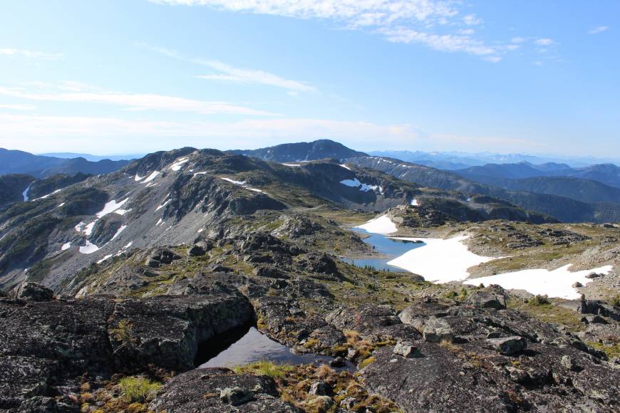
The area is spectacular; the green valleys are studded with lakes, short twisted trees tell of rough winds and hard winters, and the rocky ridges are laced with veins of white quartz, sparkly rock and crystal tarns.
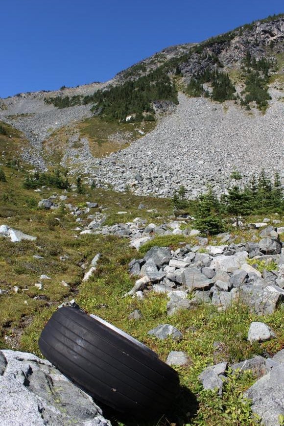
If you decide to follow the worn trail in, don’t be surprised to find an airplane tire at the bottom of the alpine basin. Up the slope lies the remains of a water bomber that crashed into the mountainside in 1974. We visited the crash site on our self-blazed loop trail and followed the worn trail back to camp after snacking on handfuls of warm blueberries.

The trail past the water bomber will take you to the saddle we came down, and reward you with some beautiful views. From there, if you want to bag Stoyoma, you should have a map and a compass handy to guide you to the peak because there is no actual trail to the top.

July was a beautiful time of year to hike Mt Hewitt Bostock, but coming back to explore the Stoyoma area in September meant no mosquitoes, perfect hiking temperatures and sun ripened trail snacks. The two mountains are near to each other as the crow flies; if you know their shapes you could probably wave to the one from the top of the other.
Before you try one of the hikes in Merritt
The map Sylvia used was the Backroad Map of Squamish, Chilliwack & Merritt. It would be a very good idea to have a copy with you on either of these two hikes.
I also recommend Organic Maps – an offline hiking app.
For more information about Merrritt British Columbia, be sure to visit the tourism website for all sorts of useful information.
Further reading on hikes in British Columbia
- 21 of the Best Hikes in BC to Add to Your Bucket List
- 10 Best Yoho National Park Hikes
- The Rainbow Range Trail Hike in Tweedsmuir Provincial Park, BC
- The Stanley Glacier hike in Kootenay National Park
- The Gwillim Lakes Hike in Valhalla Provincial Park
Click on the photo to bookmark to your Pinterest boards.
