
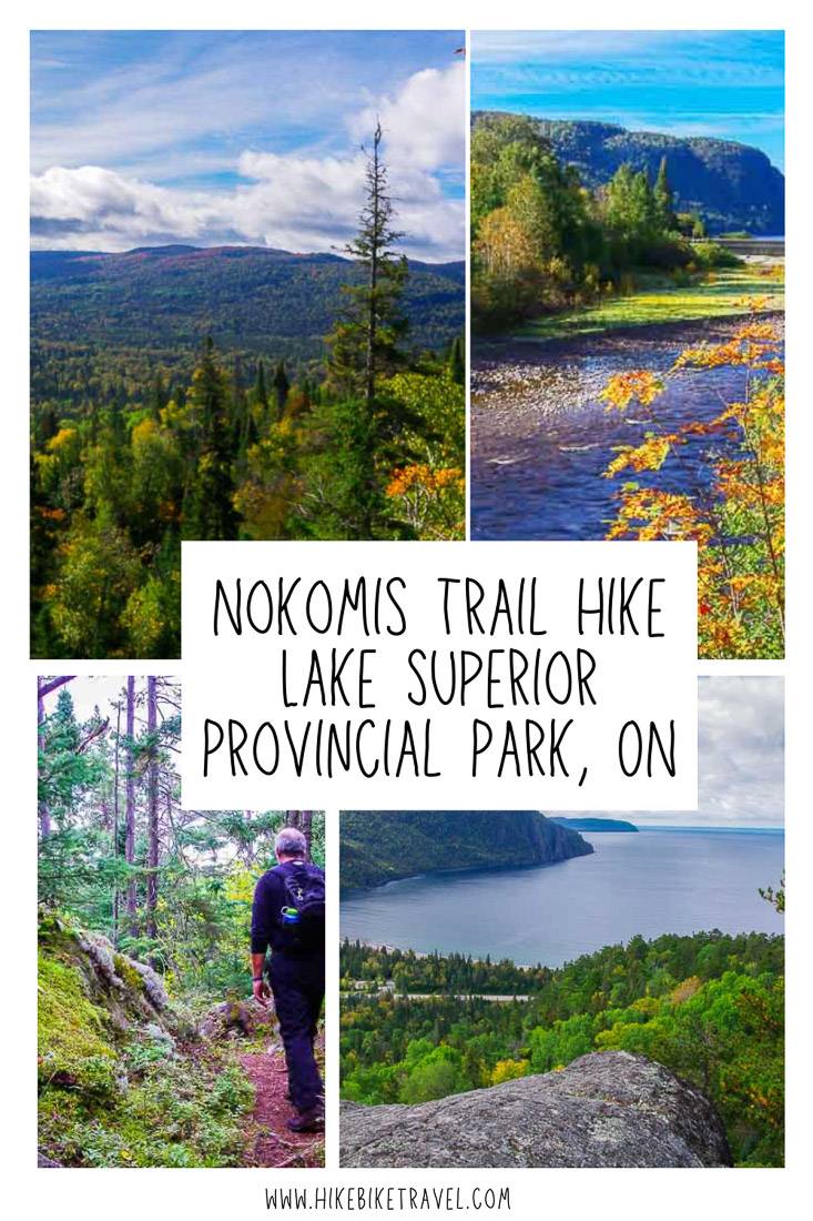
Hiking the Nokomis Trail near Lake Superior
Hiking the Nokomis Trail in Lake Superior Provincial Park is ideal for people that are either staying in Lake Superior Provincial Park – or for those who are driving through Ontario on the Trans-Canada Highway and need more than a walk on the beach for a break.
I did the Nokomis Trail hike one fall on the way back to Toronto, after a five day backpacking trip along the Coastal Trail in Pukaskwa National Park. It was the perfect length of hike to break up a drive.
This post includes some affiliate links. If you make a qualifying purchase through one of these links, I will receive a small percentage of the sale at no extra cost to you. Thank you very much for your support.
Nokomis Trail hike details
Distance: 5 km (3.1 mile) loop
Elevation gain: 152 metres or 499 feet
Time needed: 2 – 3 hours
Difficulty: Moderate
Dogs allowed: Yes, on a leash
Fees: Day use fees are in effect. They are $12.25 for a vehicle in 2024 with a discount given to Ontario seniors. You can purchase a day pass online up to five days in advance of your trip starting at 7 AM.
High praise: Lonely Planet’s Discover Canada guidebook ranks the Nokomis Trail in the top five day hikes in the country.
Don’t forget: Always pack the 10 hiking essentials – even on short hikes like this one, and let someone know what trail you’re hiking and when you’re do out.
Would you like to save this?
What you’ll see on the Nokomis Trail
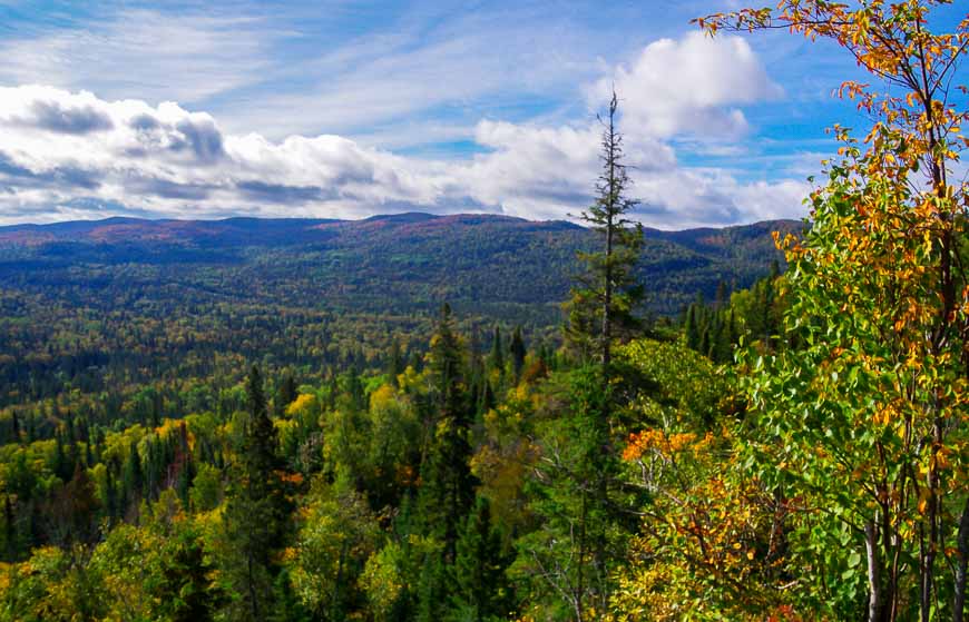
The trail sits at an interesting intersection as it marks the abrupt change in the forest.
North of the Old Woman River Valley the Boreal Forest is predominant; south is the deciduous Great Lakes-St. Lawrence Forest interspersed by boreal lowlands.
It’s particularly evident in the fall when the trees change colour to the south but remain green in the evergreen lowlands to the north.
Nokomis Trail hike description
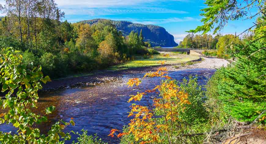
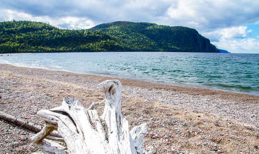
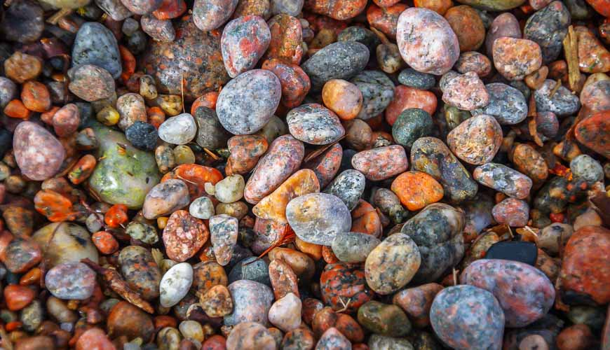
The trail follows the Old Woman River Valley over ancient cobble stone beaches, remnants of an old lake bed.
The rocks can be slick if wet here as they’re covered in moss and lichen. When you’re on the cobble stone beach look for the Pukaskwa Pit, a circular depression made by aboriginal people and believed to be a spiritual site or shelter.
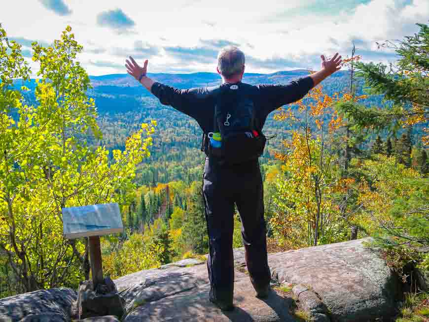
After a steep climb, about 30 minutes into Nokomis Trail hike, the first of many viewpoints appears.
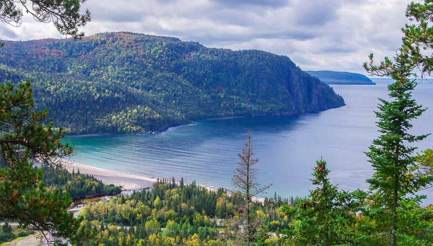
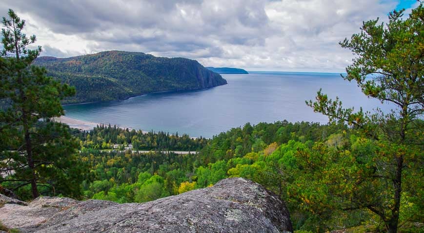
Look out to Lake Superior and admire the cliff in Old Woman Bay that rises 200 m above the water. See if you can find the immortalized woman in the rock face.
She is thought to be Nokomis – grandmother of the Ojibway demi-god Nanabozho though others have called her La Vielle – Old Woman of the Wind.
Views in the fall, from the lookouts, are stunning with the hills to the south a palette of colours. Look down to the river where black bears can sometimes be seen along its edge.
Once you’ve reached the first lookout, the bulk of the climbing is done. Continue north, hiking past beautiful outcrops of granite to reach one overlook after another. At the high point the view is simply superb and on a clear day Lake Superior’s waters look very inviting to swim – though they’re not.
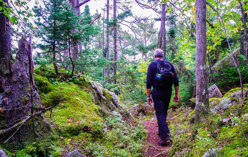
To complete the hike, descend on the well-marked trail through stunted red and jack pine trees, past beautiful lichen covered rock outcrops to a trail that parallels the highway. If there aren’t any cars, you can cross the highway and head for the beach.
It’s a fitting end to the hike and a perfect place to enjoy a picnic.
This 5 km hike offers some of the best views in Lake Superior Provincial Park. Allow two to three hours to do the loop.
Finding the Nokomis trailhead
You’ll find the trailhead for the Nokomis Trail 200 km north of Sault Ste. Marie and 27 km south of Wawa.
The Nokomis trail is located across the highway from a large parking lot at Old Woman Bay. You do have to pay for parking. It’s $7.50 for four hours of parking or $5.25 for two hours of parking.

All in all the Nokomis Trail is a great hike and a really good way to get some exercise when you’re driving along the Trans-Canada Highway.
Where to stay near the Nokomis Trail
There is excellent camping in Lake Superior Provincial Park. If you book early, you can score campsites overlooking Lake Superior. You can book campsites online.
The online reservation system opens at 7:00 AM, five months in advance of the first date of your trip.
Sault Ste. Marie
There are also lots of hotel options in Sault Ste. Marie.
The Microtel Inn & Suites has an indoor pool and fitness centre.
The Quattro Hotel & Conference Centre comes with a free breakfast.
The Water Tower Inn has an indoor pool and an onsite restaurant. I’ve had a comfortable stay here.
More reading related to travel in northern Ontario
- The Hike to Agawa Falls in Northern Ontario
- Mississagi Provincial Park: A Northern Ontario Gem
- A Challenging Hike on the Lake Superior Coastal Trail
- The Top of the Giant Hike in Northwest Ontario
- Kayaking Around Michipicoten Island in Lake Superior
Click on the photo to bookmark to your Pinterest boards.


I believe the best time to walk the Nokomis trail is towards the end of Sept. At this time the leaves are mostly all changed. From the top of the trail, Looking south you see all of the colours of the maple, yellow birch, mountain ash, etc. – reds, oranges and yellows (Great Lakes/St. Lawrence forest. Looking north the overwhelming colour is the yellows of the white birch and poplar (Boreal Forest). It is very distinct from this view. I don’t know where else you would see this.
@Dan Great point – and you’re right late September is about peak time to hike the trail.
This place is too good for hiking. I wish I could go there. I think I am flying high as I am dreaming about it now!
It’s excellent for hiking – also for camping.
I had no idea Northern Ontario was this pretty. My parents grew up around there and always talked about it when I was growing up, but I just tuned them out. Now you’ve given me a reason to take another look.
@Jody That was a beautiful trail but the 5 day backpacking trip along the shores of Lake Superior in Pukasawka was even more scenic and fantastic.
The old woman’s face is clearest on the first, third last and last photos.
She is looking up to the right on the right end of the treed ridge. She has a big nose and a protruding chin.
@John Thanks for pointing that out.
Hi Leigh, wow, what a stunning hike to break your road trip. I’ve spent some time trying to figure out the face of Nakomis on the rock face but I couldn’t find it:( (It really piqued my interest bec there’s a similar story where I grew up in the Philippines). Thanks for taking me on another beautiful hike. Love that photo of the colorful pebbles.
@Marisol You have to look at the face on an angle and then you’ll see it. Actually you’ll wonder how you could have missed it.
Hats off! You really good at getting pictures 😀
I never thought of forests being divided. It’s been a long time since we’ve done a long drive, but hiking is a good option for stretching your legs. The scenery on this hike looks beautiful. Is it all covered in snow currently? I’d be running from that snake instead of taking a photo.
@Michele It’s because of the temperatures that the forests are divided. The area is under a ton of snow right now so it will be at least another month before the trail is open.
Looks like you picked a great spot for a hiking break and during a nice time of year, too. Love seeing the colors coming out. Interesting stories about the “Old Woman”. But, sorry I could make out her face on the rock face.
@Cathy I think you need a few drinks to actually see the face. I couldn’t find it either.
You can only see the face if you’re on a boat looking towards shore; I have made out her face
Hmm.. .. you keep posting all these gorgeous pictures from parks around Lake Superior. Maybe it is time I circle the big lake and check them out for myself! Thanks.
@Cindy The Lake Superior area is so wild and so beautiful but you want to see a section where you can get close to the coast.
We did the L. Superior circle tour for our summer vacation one year. Stopped and paddled the Apostles for a few days. Beautiful country. I highly recommend!
@Carolyn Paddling in the Apostles is definitely on my wish list. Your sure gives you a sense of the lake doesn’t it.
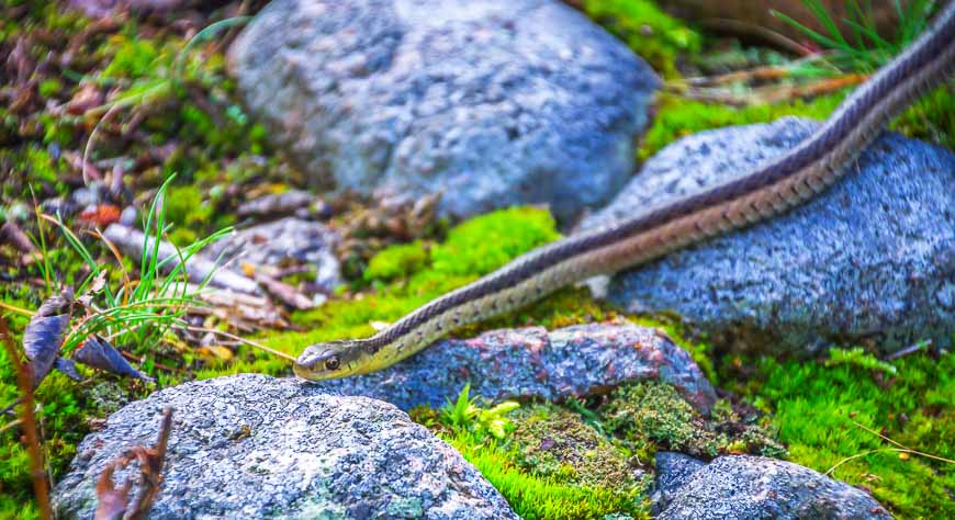
I liked the part, “a circular depression made by aboriginal people…” – very cool! These pictures, like virtually all of your’s, are the same as watching tv in HD, Leigh! Your garter snake photo didn’t display and I’m good with that seeing as I’m not a snake fan ha, ha 🙂 I absolutely love to stop on a drive and take a spontaneous hike. You can find the most amazing, beautiful surprises that you would have otherwise never seen. Good post as always, our friend!
@Mike I’m curious as to why the snake didn’t display because I checked it and it was fine.
There is one hike in the area to Agawa Falls that would be spectacular in the fall but none of us had that sort of energy after 5 solid, hard days of hiking.
Thank you for your lovely comment.