
How to Hike Coliseum Mountain in Nordegg (Trail Guide + Tips)
The Coliseum Mountain hike called Yahareskin (The Mountain with the Cap On) by the Stoney First Nations, had been on my wish list for years. But with it’s location just minute’s from Nordegg – and three plus hour’s driving time from Calgary, I figured I needed to make it into a weekend trip.
I nixed that idea after looking at weather forecasts for Banff and Kananaskis Country. While they looked cold and rainy, Nordegg looked sunny and warm. I decided to make it into a long day trip – but didn’t tell my husband where we were going until we left Calgary. Fortunately, he was fully onboard.
The bottom line – it’s about a 12-hour day if you hike Coliseum Mountain from either Calgary or Edmonton – and it is doable as a long day trip. Along the way we discovered the Cornerstone Café in Caroline – perfect for a morning latte and fresh baked treat to fuel our upcoming adventure.
The hike up Coliseum Mountain delivered everything I expected of it – a great workout, wonderful views of the front range of the Rockies, Nordegg, Abraham Lake and beyond, along with panoramic views of the coliseum itself.
This post includes some affiliate links. If you make a qualifying purchase through one of these links, I will receive a small percentage of the sale at no extra cost to you. Thank you very much for your support.

Would you like to save this?
Quick Coliseum Mountain hike stats
Distance: Approximately 13.2 km return depending on route + about 625 metres return if you add on the east summit
Elevation gain: 635 – 700 m depending on your chosen route
Difficulty: Moderate
Time: 5–6 hours plus an extra 30 minutes to do the return hike to the eastern summit of Coliseum Mountain
Trailhead location: Coliseum Trail staging area at the end of Eagle Drive.
Dog-friendly: Yes, on a leash but carry a couple of litres of water for them on a hot day. The only water is at the creek at the start of the Coliseum Mountain hike.
Best season to hike: Late spring to fall (it’s usually snow-free by June) but it’s also popular with snowshoers in winter who have the expertise.
Weather forecast: Check out Windy.com.
Don’t forget: Pack the 10 hiking essentials. Include a windbreaker as it is notoriously windy on the summit.
Please: Practice the seven Leave No Trace principles. Be sure to tell someone where you are going and when you expect to be back.

Where is the trailhead for Coliseum Mountain?
From the David Thomson Highway (Highway 11) by Nordegg, turn north onto Shunda Creek Road. Turn right at Baldy Mountain Road and then right again onto Eagle Drive. Continue to the end of Eagle Drive to reach a large parking lot.
There is an outhouse in the parking lot.


Location map
Hiking options
There are a couple of options to get to the summit of Coliseum Mountain but unless you’re a very experienced hiker who loves steep terrain, stick with the main route. It’s also a longer hike if you do the loop route as opposed to the well-traveled out and back hike.

Trail description: what to expect on the Coliseum Mountain hike
The forest section – From the parking lot head out on an easy trail behind some homes to reach a bridge over the creek. You’ll see arrows and a Coliseum sign before you cross the bridge. This is your last place to get any water.
Continue on the Coliseum Mountain trail as it travels through the trees before making an abrupt left-hand turn, marked by another Coliseum sign. Then you’re into a series of switchbacks. Some are long, some short. This is where you’ll gain the bulk of the elevation.
Please avoid cross-cutting to avoid further erosion.


Midpoint (open slopes) section of the Coliseum Mountain hike
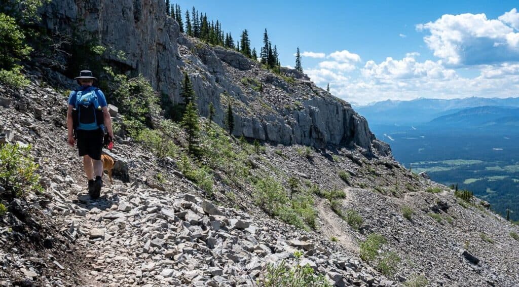
At the top of the switchbacks – after approximately 4 km of hiking, the landscape starts to open – and it gets rockier underfoot. Once you reach a meadowy section, you’ll see signs for toilets. If you must go, this is the place.
In no time Coliseum Mountain with it’s notable cap comes into view. The way forward is obvious, though some distance off. It’s wonderful hiking from here on, especially on the curved section overlooking the amphitheatre. The trail undulates through this part of the hike, climbing gradually, while traveling through a mix of spruce trees and meadows. Looking east, enjoy some great views out to the prairies.
After you cross the scree slope look for the obvious trail through the woods on your right, just as the main trail curves left. Once we completed the hike up Coliseum Mountain, we came back to this spot to climb Coliseum Mountain’s east summit.


Final ascent (ridge to the summit) – rocky, wind-exposed, panoramic view
The final part of the hike up Coliseum Mountain is rocky and exposed to the wind – but it’s short. Switchback up the rock on a well-defined trail and then stroll up the grassy slopes to reach a large cairn at sitting at an elevation of 2,040 metre or 6,693 feet.
You did it! Now find a suitable lunch spot with a view and enjoy the panorama. From the summit of Coliseum Mountain, you can see the David Thompson Highway and Abraham Lake off in the distance, Shunda Mountain and the Baldy Fire Lookout – one of the 100 or so manned fire lookouts in Alberta – and of course views out over the prairies.
Retrace your footsteps to return to the trailhead.


Side trip to hike the east summit of Coliseum Mountain
Since we were so close to the east summit of Coliseum Mountain, we decided to go for it. It adds 20 – 30 minutes of hiking time to your day, but it offers more great views over to Coliseum Mountain and out to the prairies.
There’s a short section of steeper scree with a boot-beaten path before a gentle hike to the cairn on the summit. I think it’s well worth doing.


What to bring on the hike
Dress in layers. The Coliseum Mountain summit can be cold and windy.
I’d recommend a hiking pole or two especially for the descent and good hiking shoes with support since the trail is rocky in places.
Don’t forget to take pack a protein-rich lunch and throw in some energy bars.
Take a minimum of two litres of water on the Coliseum Mountain hike – more if it’s a hot day. Water purification tablets or a water filter would be handy to fill water bottles at the stream for the drive home. There is no other water on the trail.

Safety notes
- Don’t count on cell service. Carry an InReach Mini 2 or other satellite communication device in case you run into an emergency.
- You may see wildlife. Be bear aware and carry easy to access bear spray. I like mine in a bear spray holster so I don’t accidentally set it off.
- Weather changes quickly in the mountains. Pack extra clothing and rain gear in case a storm rolls in.

Where to stay in Nordegg
There are also lots of other campsites and campgrounds along Highway 11 and heading further east. Most don’t require reservations.
Check out Okt Häus in Nordegg – a large home with five bedrooms that is perfect for a bigger group. It comes with a hot tub and fire pit.
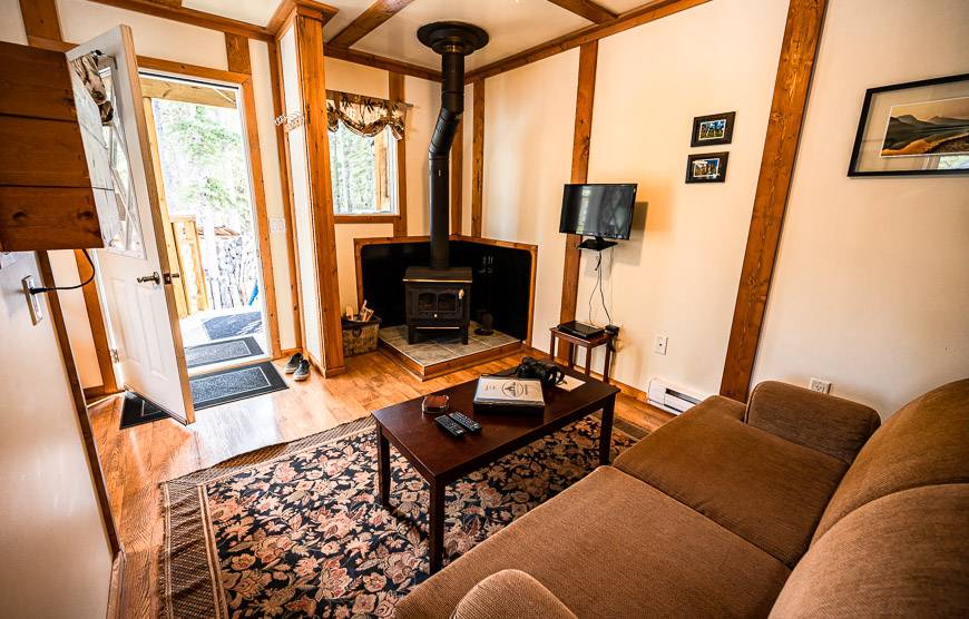
Expanse Cottages not far from town is a good option too. Units come with a fire pit, kitchenette, living room and more.
More hikes I think you’ll enjoy
- Allstones Lake Hike (+ Allstones Ridge)
- Coral Creek Canyon Hike near Abraham Lake
- Best Hikes Along the Icefields Parkway
- Sunset Pass – Sunset Lookout Hike, Icefields Parkway
- The Hike to Siffleur Falls in David Thompson Country
Click on the photo to bookmark to your Pinterest boards.


