Whaleback Ridge Hike Near the Cowboy Trail
For the first time in weeks, John and I had a weekend together where we could both be outside hiking. Just the week before, he had regained the vision in his left eye, after losing it for the better part of seven weeks because of a retinal detachment. You’re not allowed to exert yourself or go to any altitude, so all trips to the mountains were off limits. We opted for the Whaleback Ridge hike, accessed off the Cowboy Highway south of Longview and Millarville.

Would you like to save this?
This post includes some affiliate links. If you make a qualifying purchase through one of these links, I will receive a small percentage of the sale at no extra cost to you. Thank you very much for your support.
Trailhead location for the Whaleback Ridge hike on the Cowboy Highway
The parking is simply a pullout 4 kilometres south of Secondary Road 520 and 30 kilometres from the junction of Highway 22 and Secondary Road 533.
Useful information for the hike
Mileage: Highly variable depending on how far you decide to go.
Time needed: We did the return Whaleback Ridge hike in 3.5 hours. You could easily spend a few more hours exploring the ridge.
Level of difficulty: Easy, but many people won’t like the lack of signage on the Whaleback Ridge hike.
Don’t forget: Pack the The 10 Hiking Essentials Everyone Should Carry and let someone know where you’re going.
Dogs: Allowed but I’d suggest you keep them on the leash, especially with so many horses around.
Location: The hike isn’t too far from Waldron Ranch – the “largest deeded block of land on the eastern slopes of Alberta.” The Nature Conservancy of Canada was involved in a conservation easement agreement that helps protect the headwaters and land from being cultivated and turned into subdivisions.
The Whaleback Ridge hike is in horse country
The trailhead was packed with horse trailers by the time we got there. But this is big country and over the course of four hours we saw only four horses and five humans.
It seems it was hunting season as the few people we saw carried guns. We stayed together and I kept my whistle handy. I think it would have been hard to mistake John and I and the dog for a deer or a moose. Still, late fall is probably not the smartest time to be doing the Whaleback Ridge hike.


Details of the Whaleback Ridge hike
There is no marked trail per se on the Whaleback Ridge hike. We had a trail description – itself a little vague – but in the end it didn’t matter.
Basically you follow a road up a hill from the highway where there is the odd cow about. Avoid them. After passing a large pond to the south, the hike takes you up the slopes of Black Mountain (not much of a mountain) through some woods – all the time while on a track.
Once you emerge from the woods – you can see the Whaleback Ridge off in the distance. In total, it’s 30 kilometres long so there are endless opportunities for exploring once you gain the ridge.
The only blight on the landscape was huge power lines.

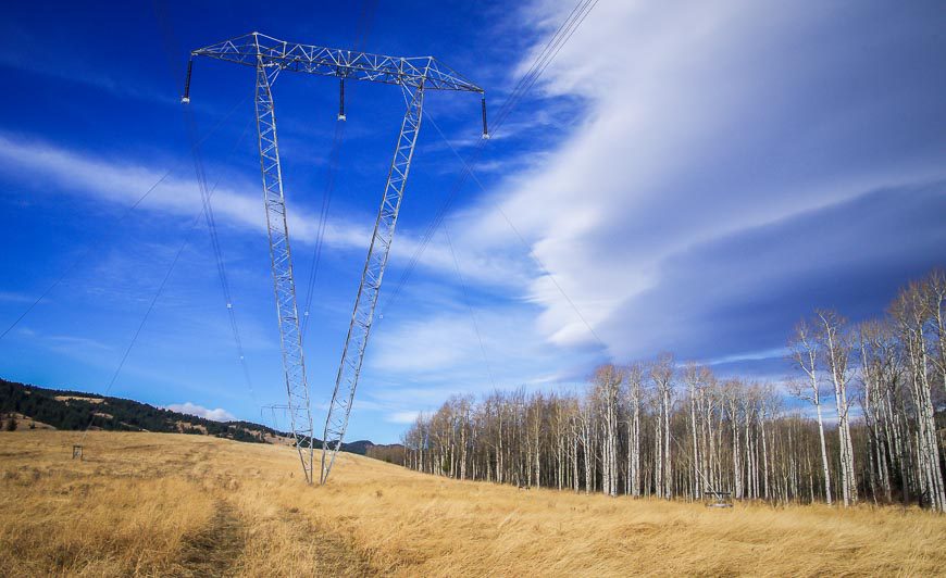
To get to the Whaleback Ridge you must cross a small creek where the road turns north – and then walk beneath the power lines.
From there continue on the trail up the coulee. At the top you can head in a few directions. We chose to go south up another hill and over a barbed wire fence.

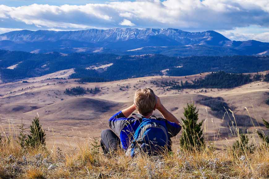
The views at the top of the Whaleback Ridge hike are superb. The expansive Bob Creek Valley lies below and rising in the distance are the foothills of the Rocky Mountains.


Although the Whaleback Ridge hike doesn’t offer the scenery you’d see if you went into the mountains, it is still a special area worth exploring. In total, approximately 29,000 hectares is protected from oil and gas development. And although we didn’t see any large animals, the Whaleback area is the home of wolves, grizzly bears, cougars and a large herd of elk.
According to Bill Corbett (author of Day Trips from Calgary)
“The Whaleback is Canada’s largest and healthiest montane landscape, characterized by a relatively dry climate and a patchwork of grassy slopes and dense forest.”
Further reading on hiking in Alberta
- 18 of the Best Banff Hikes You Can Do in a Day
- 12 Kananaskis Trail Hikes in Alberta With a View
- Hiking in Alberta: 16 of the Must-Do Day Hikes
- Alberta’s Fabulous Table Mountain Hike
- Best Hikes in Jasper National Park
Click on the photo to bookmark to your Pinterest boards.


I know the trail is not marked but I had difficulty following your directions: cross a small creek where the road turns north – and then walk beneath the power lines.
Did you go north or south beneath the power lines?
@Janis From the photo we walked up beneath the power lines. You do gain about 375 m of elevation in total. They didn’t have Organic Maps when we di the hike, but if you download the app you’ll see the ridge location. You can follow any trail that will get you to that point but you almost need a sixth sense to get to the ridge.
thanks!!
So glad John’s eye is better, Leigh! I love that picture of him looking across the valley at the Rocky Mountains. Of course my favs are always ones that include Torrie 🙂
@Mike We bring Torrie on any hike that doesn’t require a lot of climbing as she is just too stiff at the end of the day now. It makes me sad.
This area kind of reminds me of Custer State Park and the Black Hills in South Dakota with the rolling grassy hills and the mountains in the background.
@Ted Really rather grand country even though the scenery wasn’t as in your face beautiful as the Rocky Mountains.
Looks like everyone was happy. With that beautiful scenery, why not? Good to hear that John’s eye had healed. Thanks for linking up this week. #TPThursday
Oh my gosh, so sorry to hear John’s been laid up for so long but good to read his vision returned and he’s up and about again — and what beautiful scenery for him to be looking at on his first trip out and about!
@Jackie He’s very happy to be doing all his regular activities as you’re not supposed to get your heart rate up after the surgery for a good six weeks – even more if the doctor’s had their way.
It’s nice to see that John is on the mend and has recovered nicely. This is such stunning scenery and it’s such a blessing that it’s been protected from oil and gas development. I love all those colors and all those cloud formations. I’m glad you were able to do this hike before the snow swept in.
@Mary It’s hard to get over what a difference a day makes. It was a treat to sit and have lunch with such a grand view.
You’re making me homesick with this post! Agree that the mountains offer more spectacular scenery, but will a very special place! Interesting about the hunters, I hadn’t thought about that when hiking it in fall but makes sense. Both time I’ve been there it was in summer.
@Laurel It turns out the Nature Conservancy has just purchased and organized for another big chunk of land to be protected almost next door to where we were hiking. It will be great for the wildlife. I’ve actually heard that the numbers of hunters are dropping. Everyone is on their devices instead.