Years ago, I came across a post on the McGillivray Canyon hike and filed it away as a hike that looked interesting. And what a unique hike it turned out to be!
The trail takes you from the parking lot near the noisy Trans-Canada Highway, through pretty woods with dappled light to the edge of McGillivray Canyon. A climb ensues followed by a steep descent – that can be challenging in winter. There’s about a 300-metre stretch with exposure where you really don’t want to fall. But once in the canyon, the hiking is easy, and the experience of walking past steep canyon walls is glorious.
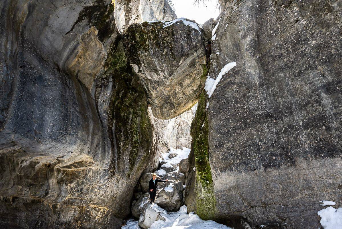
McGillivray Canyon is one of several slot canyons near Canmore. It doesn’t see anywhere near the numbers of people that Grotto Canyon gets because of the difficulty of getting into it. If it was easy, it would be overrun with people as the chockstone near the end of the trail is Instagram worthy.
In winter the large boulders are snow covered, so it’s a good idea to follow the trail of those who have gone ahead of you. The rest of the year, save for the spring melt or flood, there is a small stream that flows through the canyon. You won’t run into many people on the McGillivray Canyon hike, though at certain times of the year you may see rock climbers on the near vertical faces.
The landscape in the canyon is dramatic, especially when you come to the chockstone, a massive boulder wedged between the two canyon walls. Even though it’s been there for a good long time, it’s unnerving to walk under it.
Check out my Instagram reel to see what the hike looks like.
This post includes some affiliate links. If you make a qualifying purchase through one of these links, I will receive a small percentage of the sale at no extra cost to you. Thank you very much for your support.

McGillivray Canyon hike summary
Permits: You do need a valid Kananaskis Conservation Pass. Purchase online before you go. It’s $15 per day or $90 per year with up to two cars at the same address.
Distance: Approximately 4.4 km round trip
Elevation gain: 136 m or 446 feet
Time needed: 1.5 – 2.5 hours depending on how much time you spend enjoying McGillivray Canyon.
Level of difficulty: Easy to moderate with one caveat – there is serious exposure most people won’t like on the trail above the canyon walls. In winter it’s icy. If you attempt it without icers, you could get yourself into serious trouble. Once in McGillivray Canyon it’s straightforward.
Don’t forget: Let someone know where you are going and when you are due back. Carry the hiking essentials and an extra pair of dry socks.
Bears: I’d recommend carrying quick to access bear spray in all but the coldest winter months.
Dogs: We didn’t bring our dog and I’m glad we didn’t because of the steep, icy descent. It’s doable for some athletic dogs but is it a good idea? My husband says yes, and I say no. Better though when the snow and ice have disappeared.
Equipment: In winter takegood icersthat grip the ice on a slope and not the walk-in-the-neighbourhood kind of icers with metal knobs. I’d recommend ahiking poleas well – good for balance and testing water depth in the pools in the canyon.
Please: Practice Leave No Trace principles. The canyon appears pristine, and it would be great to keep it that way.
Weather forecast: Check the forecast before you go.
Trail conditions: It’s hard to check trail conditions for the McGillivray Canyon hike because this like many trails in Kananaskis is an unofficial trail. Use some common sense. If it’s rained hard, there’s been a big dump of snow, or a horrific windstorm has passed through, give it a pass for at least a few days until things settle down.
Take personal responsibility: There are risks involved with this hike. Make sure you’re aware of them and do everything to mitigate them before you go. You are responsible for your own safety. Take your fully charged cell phone and an emergency location device like aGarmin InReach Mini 2.

Finding the trailhead for the McGillivray Canyon hike
If you’ve driven the Trans-Canada Highway between Calgary and Canmore, then you have passed the unmarked entrance to the parking lot and the trailhead for the McGillivray Canyon hike.
You CAN ONLY get to the parking lot from the east bound lane on the Trans-Canada Highway.
If you’re driving west on the Trans-Canada Highway
Get off at Dead Man’s Flats. Go over the overpass to pick up the Trans-Canada Highway heading east bound. Zero your odometer at the top of the on ramp. Drive for 3.5 km from the top of the on ramp. keeping a close eye out for the pullover. It’s obvious and it will be at about the 3.6 – 3.7 km point. When you can see Lac des Arcs in the distance, you’re almost at the pull off. Beware of cars behind you.
If you’re driving east on the Trans-Canada Highway
From Canmore it’s about a 10-minute, 11 km drive. Follow the instructions above from the on ramp from Dead Man’s Flats.

McGillivray Canyon hike description
There is no signage for the McGillivray Canyon hike, but the route is on theGem Trek Canmore and Kananaskis Village Mapand we found Organic Maps, an offline hiking app to be very helpful.
From the parking lot head out on the obvious trail that starts by two large rocks. In short order pass a trail coming in on your left and a sign saying Trans-Canada Trail. Ignore it and keep walking on what the Gem Trek map calls the Bow Corridor Link Trail as it curves around and heads through a thick stand of trees.
In short order you’ll see a yellow sign saying, “Alberta Wildland Provincial Park boundary.” Turn left onto the trail John is pointing at in the photo below.


Continue walking through pretty forest to reach the start of the canyon. You will see a rough trail down to McGillivray Canyon, but don’t take it. Back in 2021 Alberta Parks pulled all the ladders and ropes out of the canyon as it deemed them to be unsafe. There is now an upper canyon bypass trail and that is what is described in this blog.

The trail was well tramped down when we did the McGillivray Canyon hike but could be difficult to follow after a fresh snowfall. You might want to wait a day or two for other hikers so you can follow their tracks.
When you reach a small – as in maybe a one metre climb up a rock with roots where you’ll probably need to use your hands for the first time, you’ll need to look for a trail on your left taking off from beside the only large boulder in the immediate area. This is the canyon bypass trail. We went straight by it as there is a faint trail and had to bushwhack up to it about 10 minutes later.
Once you’re on the bypass trail, it’s very straightforward. Most of the elevation gain takes place over the next half kilometre or so. As you get close to the steep descent into the canyon, you can’t help but notice the drop-off on your right. Focus on your feet and avoid tripping. It’s a steep, slippery descent to the canyon bottom, but fortunately there are quite a few trees to grab. I found a pole helpful in places here too.


Once you’re in McGillivray Canyon it’s all easy going. You’ll be happy to know that the hike out of McGillivray Canyon is way easier that the descent into it. And the canyon is a beauty. We took our time, stopping to admire the rocks along the way. We saw lots of climbing ropes and bolted routes up sheer canyon walls. It would be fun to see the rock climbers in action here.
We did the McGillivray Canyon hike in March after a warm spell so there were pools of standing water you had to get around. A pole helped for balance and to probe to see how deep the pools are. If you get a soaker, a dry pair of socks would be nice to have.


Final thoughts
I love canyon hikes – and in fact some of the best days of my life have involved canyons. Cue a full day canyoning experience in Jasper National Park and one in Utah’s Escalante Wilderness. Both of those were guided hikes that required ropes and rappels. There is nothing technical about the McGillivray Canyon hike, but you do have to feel comfortable with some exposure. Turn around if it’s too much for you!
Location map showing the parking
More great day hikes near the canyon
- Heart Creek Bunker Trail near Canmore
- The Fantastic Hike to the Summit of Ha Ling Peak
- The Heart Mountain Hike near Canmore
- The Jura Creek Hike Near Canmore, Alberta
- Pigeon Mountain Hike near Canmore
Click on the photo to bookmark to your Pinterest boards.
