If you’re looking for a great hike that won’t take all day and is relatively close to Calgary, you would do well to choose the Nihahi Ridge hike.
The actual ridge is 10 km long though you only hike a fraction of it. However, there is the option to do a scramble to the South Summit. The trailhead for the Nihahi Ridge hike located at Little Elbow Campground, is just an hour’s drive from Calgary via Highway 66 near Bragg Creek.
This post includes some affiliate links. If you make a qualifying purchase through one of these links, I will receive a small percentage of the sale at no extra cost to you. Thank you very much for your support.
Nihahi Ridge hike summary
Distance: 10 km or 6.2 miles round trip plus some walking from the parking lot to the trailhead. Additional mileage is possible depending on how far you go along Nihahi Ridge.
Elevation: 735 m or 2,410 feet
Difficulty: Challenging if you go to the end of Nihahi Ridge.
Time needed: 3 – 5.5 hours
Best time to hike: The trailhead is accessible from May 15 – November 30th but summer and early fall are the best times to hike it.
Dogs allowed: Yes, on a leash but carry extra water for them.
Trail conditions: Be sure to check trail reports before you go.
Permit: To do this hike you will need a Kananaskis Conservation pass.
Bears: Don’t forget the bear spray and make sure it’s accessible.
Campground: The Little Elbow Campground (open from May 15 – September 18) is within a few minutes walk of the Nihahi Ridge trail.
Map: Gem Trek Bragg Creek and Sheep Valley

Finding the turnoff to the Nihahi Ridge hike
Walking along the trail beside the Little Elbow River is a very pleasant way to start hiking – but it is a means to an end as the actual trail up to Nihahi Ridge is a few kilometres from the parking lot. The initial part of the hike is flat and easy.
At the end of the Little Elbow Campground you must continue past a barricade on a dirt road. You’ll finally see some signage for the Nihahi Ridge hike. Continue for about a kilometre until you find the turnoff on the right to Nihahi Ridge.
Then the real work begins. You start climbing through the woods, albeit on a gentle grade initially. After about 40 minutes of hiking on an increasingly steep trail you reach a meadow and the grade flattens.
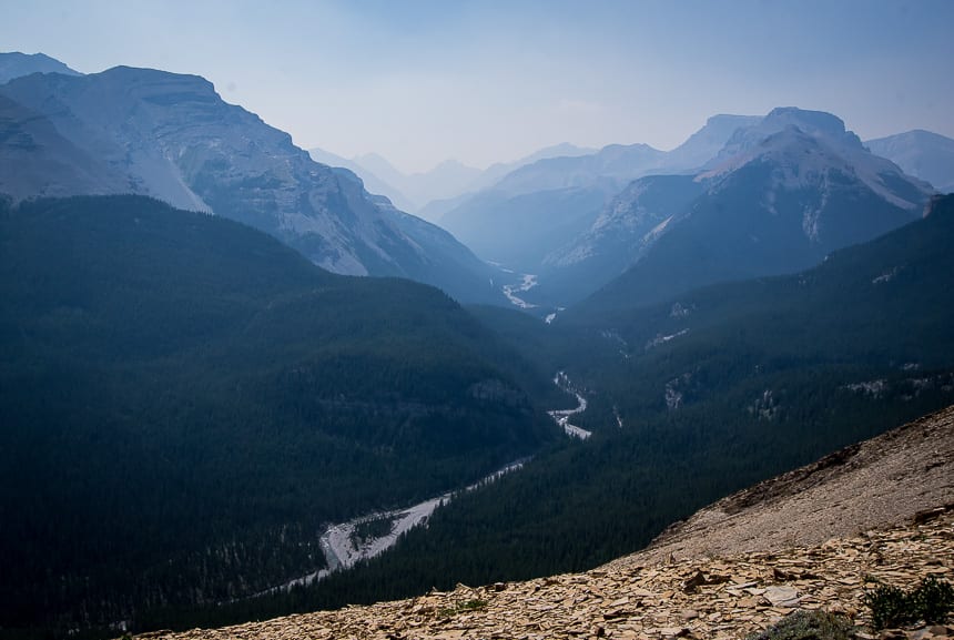
From the meadow you get a good view of where you’re going as you can see the ridge in the distance. (Photo below.) You’ll be through the meadow and back into the woods in no time. The next notable spot you’ll reach is a rocky ledge with a drop-off though steel cables are on one side to prevent you from falling. It’s not as scary as it sounds.
A few minutes later you get quite lovely views of the meadow you just crossed along with a view of Forget Me Not Ridge across the river.
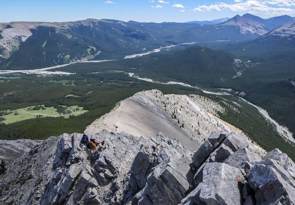
The trail steepens but the views on either side of the ridge are quite marvelous, despite the day being a little smoky and hazy. We stick to the left as we approach the ridge and follow the outcrop for about 15 minutes until we reach an opening where we can scramble up.
In total it took us about 45 minutes to go from where the guard rails were to the south end of the ridge. From where we stopped it’s a scramble to the summit with reportedly a bit of exposure near the end. With two hot dogs, we were content to call it a day and enjoy our lunch with a view.


The harder part of the Nihahi Ridge hike
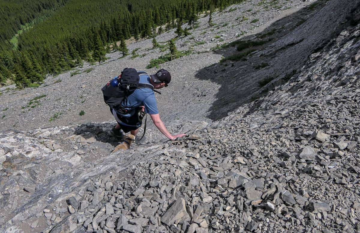
My son and husband went back another time to hike the Nihahi Ridge and continued until they felt it was unsafe to go any further.
The further you go the more gnarly it gets, so be sure to know your limits when you do the Nihahi Ridge hike. My son stopped before my husband – but his lunchtime spot still had exposure – and you had to watch your footing on the way down.

Don’t forget the water
The descent off Nihahi Ridge went quickly for my daughter and I. We were back at the river in 90 minutes. If you do bring dogs, especially on a hot day carry a lot of water as there is none on the trail.
We gave each dog 2.5 litres of water and that wasn’t enough. I don’t think we appreciated how hot the day was going to be when we started.

How to find the Nihahi Ridge hike trailhead
Take Highway 66 from Bragg Creek all the way to the junction with the Powderface Trail. Turn left to stay on asphalt and follow it towards the Little Elbow Campground.
When it turns to dirt road, continue straight for about 200 m. Look for parking for about 10 cars on your right – across from the Harold Chapman pedestrian bridge. (You won’t be able to see the bridge immediately from the road.)
If you can’t find parking here, retrace your steps to the stop sign. Turn right and follow it around to find a larger parking lot.
To start hiking look for a trail leading down from the small parking lot. You’ll see the Harold Chapman pedestrian bridge. Don’t cross it but follow the trail to the right as it parallels the road in the campground. The Little Elbow River will be on your left.
Follow it for about a kilometre on mostly level ground to reach the end of the Little Elbow Campground and a barricade. You’ll find a map here which will help you sort yourself out.
Go past the barricade and continue walking down the dirt road. After about 10 minutes you’ll see a sign on your right pointing to Nihahi Ridge. From there it’s about 2.2 km one way to the top.
Location map of the Nihahi Ridge hike
A few things you might find useful on the Nihahi Ridge hike
Take a sun hat with a brim as this area can get hot in summer.
You might like an inflatable seat cushion to make your stop at lunch more comfortable.
And if you’re in need of hiking poles I’d suggest collapsible ones, ideally made of carbon because of their weightless quality.
A Garmin InReach Mini 2 is a good device to take in case you have an emergency – and it can be route finding if you buy that plan .
Further reading on more hikes in the Bragg Creek area
- The Powderface Ridge Hike near Bragg Creek
- The Year Round Prairie Mountain Hike near Bragg Creek
- The Fabulous Forget–Me-Not Ridge Hike
- Canyon Creek Ice Cave Hike Near Bragg Creek
- The Fullerton Loop Hike in Kananaskis
Click on the photo to bookmark to your Pinterest boards.
