
Glacier Crest Trail – Glacier National Park, BC
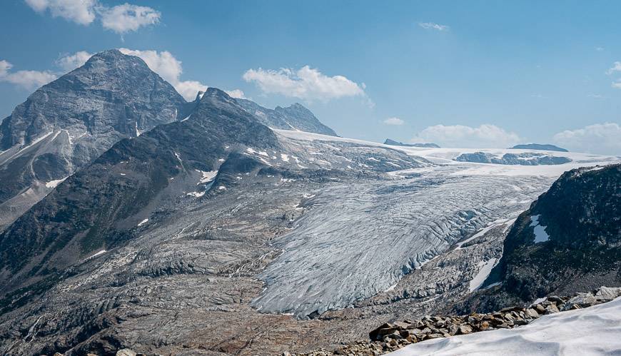
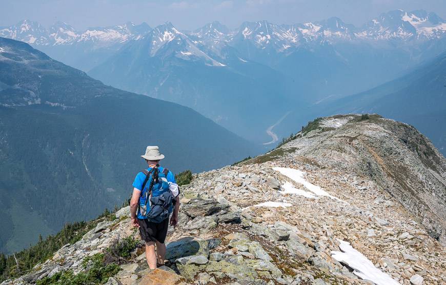
The Glacier Crest trail in Glacier National Park, British Columbia rewards with panoramic views of Mount Sir Donald and the Illecillewaet Glacier to the east.
To the west enjoy views of the Asulkan Glacier along with an unparalleled mountain landscape that includes Abbott Ridge, Perley Rock, the Rogers Pass summit, and Eagle Peak to name but a few mountain peaks.
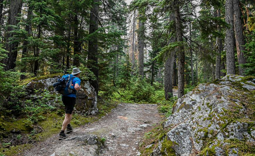
It is well worth the 958-metre climb to experience the beauty of this hike. The hike really offers a bit of everything from easy walking through ancient temperate rainforest to a stiff climb up scree and rock. Once you break through the trees, the views will propel you forward.
This post includes some affiliate links. If you make a qualifying purchase through one of these links, I will receive a small percentage of the sale at no extra cost to you. Thank you very much for your support.
Glacier Crest trail summary
Distance: 11.4 km return hike
Elevation gain: 958 metres or 3,143 feet.
Time needed: Allow 6 – 7 hours
Best time to hike: July through till mid-September when the snow starts to fly.
Get on the right time zone: Glacier National Park is on Pacific time, one hour behind Mountain time. Watches and electronic devices may not sync properly.
Permits: You will need a national park pass to do the hike.
Trail conditions: Always check trail reports before you go. In summer 2022 the snow was still present in mid-July at higher elevation, whereas in July 2021 it was long gone, so expect year to year variability. The same goes for the fall. Avalanche danger can be an issue even in summer if the snowpack hasn’t melted.
Be prepared: This is bear country so carry bear spray that is easily accessible and the hiking essentials. The weather can be very different up high.

Would you like to save this?
This post includes some affiliate links. If you make a qualifying purchase through one of these links, I will receive a small percentage of the sale at no extra cost to you. Thank you very much for your support.
Finding the trailhead for the Glacier Crest trail
The trailhead is located at the end of the road near the Illecillewaet Campground, approximately a kilometre in from the Trans-Canada Highway.
The Illecillewaet Campground is well-signed in either direction on the Trans-Canada but its a bit tricky to access the first time when you’re driving west.
The Illecillewaet Campground and trailhead is 3 km west of the Rogers Pass summit. If you’re driving east, you’ll simply turn right onto the road that takes you to the campground.
If you’re driving west, you actually drive past the campground about a kilometre to reach a U-turn-Lane. Be sure that you’re in the far-left lane in advance. There’s a warning sign that a U-turn-Lane is coming up. Turn left into the U-turn lane and then drive east on the Trans-Canada, getting off when you see the signs to the campground.
Glacier Crest trail route description
The hike shares the same initial trailhead as Abbott Ridge, but just past the ruins of Glacier House, about 10 minutes in from the parking lot, head left and not right on a well-signed trail. In fact, signage for all the trails starting from the Illecillewaet Campground are excellent.
The initial 1.4 km of hiking through the ancient forest is flat and easy. On this section of trail, we saw bear scat, but it was several days old.
Shortly after crossing the bridge over Asulkan Creek, the Glacier Crest Trail heads left at a signed intersection. The Asulkan Valley Trail goes right.
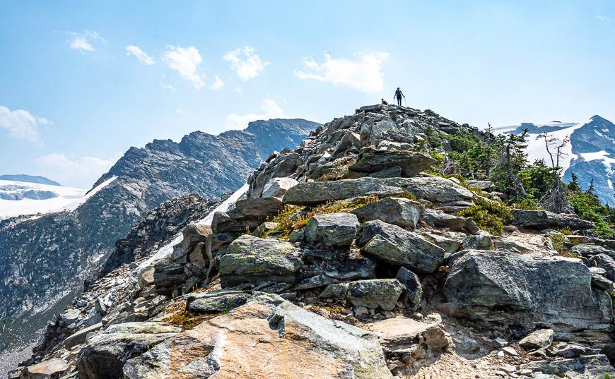
Climb through the forest with the odd peek-a-boo view. When you leave the trees behind, follow a well trodden trail on a mix of dirt and rock slabs to reach a steep climb up a hillside. This is the hardest part of the hike but its short. Coming down is trickier, just because its slippery on twist-your-ankle type ball-bearing sized rocks.
At the top of the hill, the views really unfold. In fact it feels like you can reach out and touch the Illecillewaet Glacier.
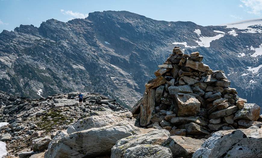
From here you have one final ridge to climb. In about 10 minutes you’ll be at the summit cairn. It’s a great place on a calm day to stop for lunch and simply enjoy the sublime beauty of your surroundings.
We saw a fraction of the people on this trail compared to the more popular Abbott Ridge trail. If you could only do one hike in the park, I’d sure have a difficult time picking between the two!
Glacier Crest Trail photos


Map of the Glacier Crest trail
You’ll find the Glacier Crest trail to the west of the Illecillewaet Glacier and south of the Great Glacier Trail.

Some things to know and take on your hike
I’d recommend that you take either a water filter or purification tablets – especially if its a hot day.
Consider carrying an InReach Mini in case of an emergency.
Where to stay near the Glacier Crest trail
If you’re looking for comfort, either stay at Heather Mountain Lodge just outside the eastern gates of Glacier National Park or in Revelstoke.
Suggestions in Revelstoke include Eleven Revelstoke Lodge, Sutton Place Hotel at Revelstoke Mountain Resort or Boulder Mountain Resort.
You can stay at the Illecillewaet Campground, which is also the trailhead for many hikes in Glacier National Park. It is located 3 km west of the summit of Rogers Pass. It’s available on a first come-first served basis. Check back with Glacier National Park for what campgrounds will be open in 2025.
There is also the option to book a bed in the A.O. Wheeler Hut, run by the Alpine Club of Canada. In summer there are 30 beds.

Further reading on things to do in BC
- 3 Nakusp Hot Springs in BC That Are Worth a Visit
- The Hermit Trail Hike in Glacier National Park BC
- 11 Things to Do in Summer in Revelstoke
- Two Standout Hikes in Merritt, BC
- Things to Do in the Columbia Valley, BC & Nearby
Click on the photo to bookmark to your Pinterest boards.


