
The Abbott Ridge Trail in British Columbia’s Glacier National Park (often confused with Montana’s national park that goes by the same name) is the must do hike in the park despite its length and significant elevation gain. After hiking the Hermit Trail in the park a few years ago, I had an inkling I’d be in for a treat.
Abbott Ridge is named for Henry Abbott, a mountain and railway man who helped build the Canadian Pacific Railway. The Abbott Ridge trail in the rugged Columbia Mountains isn’t an easy one, but it is straightforward. There are no route-finding issues or scary moves you must make. But you do have to hike a minimum of 13.6 km return with an elevation gain of 1,029 m (3,376 feet).
This post includes some affiliate links. If you make a qualifying purchase through one of these links, I will receive a small percentage of the sale at no extra cost to you. Thank you very much for your support.
Abbott Ridge Trail summary
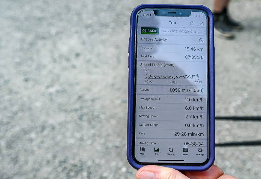
Length: 6.8 km one way on the short route, or 15.5 km total if you go up the short route and descend the long route
Hiking time: 5.5 – 7 hours return depending on your speed
Elevation Change: 1,029 m (3,376 feet) on the short loop, 1,059 m (3,474 feet) on the full loop trail
Level of difficulty: Hard because of the elevation gain and the number of hours of hiking. It is a hike for older kids only.
Best time to hike: Plan to hike from mid-July (or after the snow has left) until mid-September or whenever the snow starts to fly again.
Trailhead: Illecillewaet Campground off the Trans-Canada Highway.
Trailhead Coordinates: 117°29’31″W 51°15’49″N
Don’t forget: Always pack the hiking essentials and let someone know when you’re due out.
Map: Hard to find so I recommend Organic Maps– an offline hiking app.
Permits: You will need a Canada National Park entry pass. You can purchase daily or yearly passes depending on how often you plan to visit.
Trail conditions: Always check trail reports before you go. In summer 2022 the snow was still present in mid-July at higher elevation, whereas in July 2021 it was long gone, so expect year to year variability. The same goes for the fall. Avalanche danger can be an issue even in summer if the snowpack hasn’t melted.
Fires: Given the frequency of fires in BC, I’d recommend downloading the BC Wildfire Service App available on Google Play.
Bears: This is major grizzly bear country. Be bear aware, carry bear spray and know how to use it. It should be readily accessible – and reachable at a moment’s notice. I recommend keeping your bear spray in abear spray holster.
Good to know: Glacier National Park is on Pacific time, one hour behind Mountain time.

Abbott Ridge Trail hike highlights
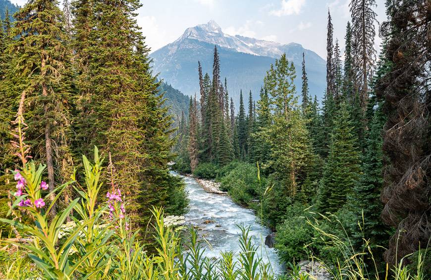
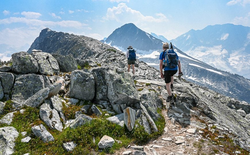
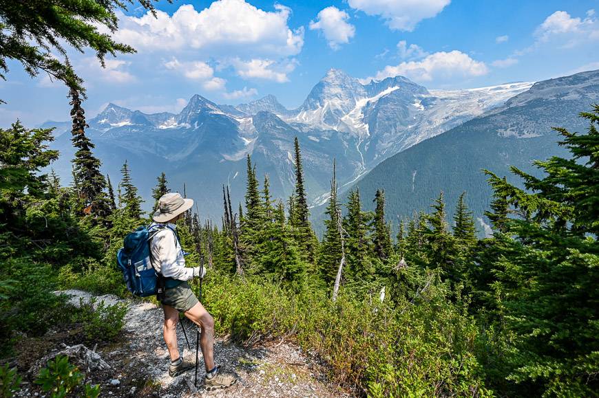
The hike starts in an ancient rainforest and climbs up into the alpine tundra where you enjoy phenomenal glacier and mountain views from your finish on a narrow ridge. Despite appearances from the approach to the ridge, the hike feels like a true mountain-top experience.
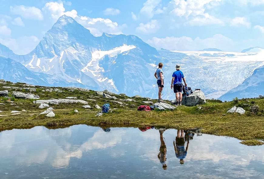
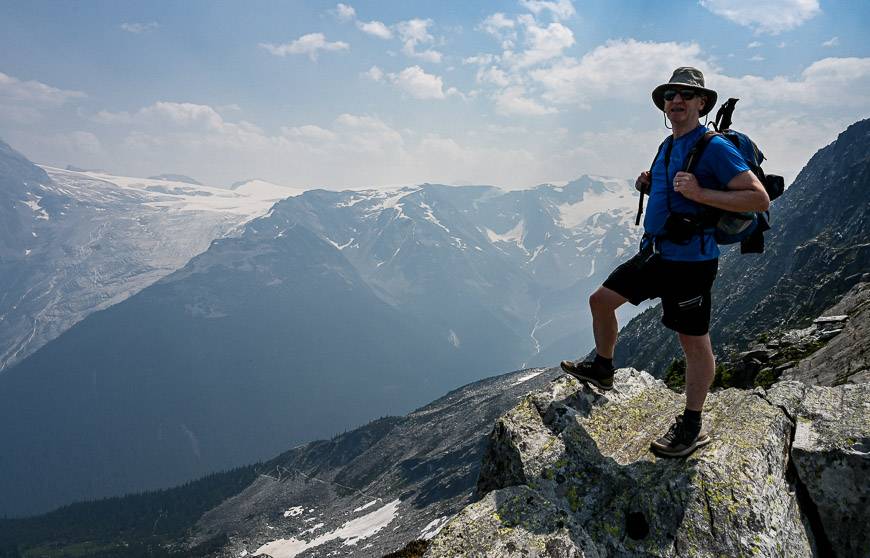
Some of the highlights of the hike include views of the Asulkan Valley and Glacier, Vaux Glacier, Illecillewaet Glacier as well as Mount Abbott, Mount Sir Donald, and Uto Peak.

Abbott Ridge trail description
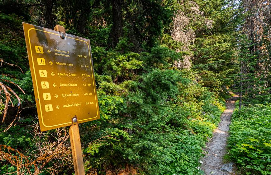
The Abbott Ridge trail heads up a road from the campground and turns right. You’ll see signage for the trails in the area almost immediately. If you look left, you’ll also see the A. O. Wheeler Hut, run by the Alpine Club of Canada.
Head for the ruins of Glacier House, a 90-room hotel with a bowling alley and observation tower. It was operated by the Canadian Pacific Railway from 1887-1925, attracting people from all over the world.
Swiss climbing guides were brought to the hotel in 1899 to take people up mountain peaks. The railway is responsible for building many of the steep trails in the area as access routes for the mountain climbers. When the railway no longer ran in front of the hotel in 1916, the popularity of the place declined and eventually closed in 1925. It was torn down in 1929.
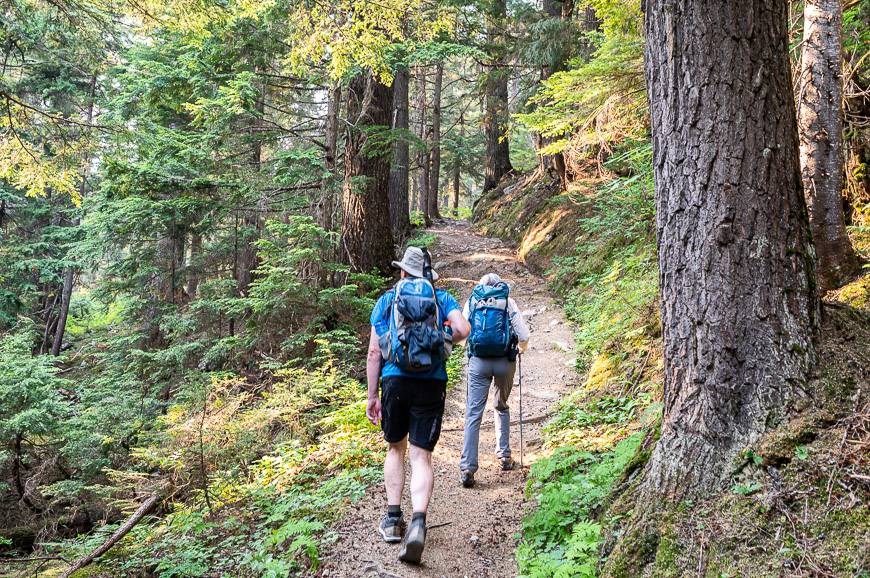
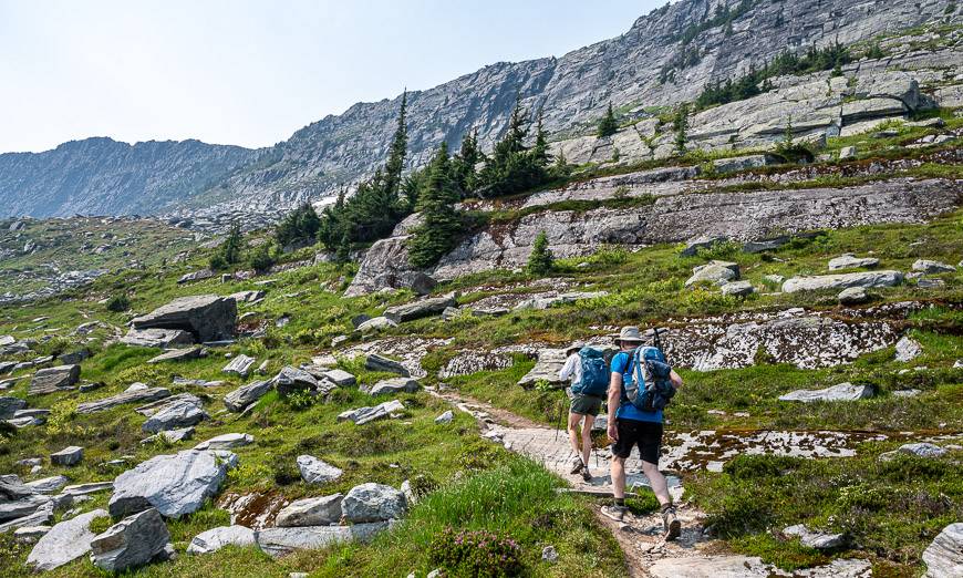
A short distance after you pass a noticeboard with the latest wildlife sightings and Glacier House, you turn right onto a signed trail for Marion Lake and Abbott Ridge. The climbing starts gently at first on a series of switchbacks through gorgeous stands of old rainforest.
There are some monster big trees in this section. Reach Marion Lake after climbing 2.2 km and gaining 425 m.


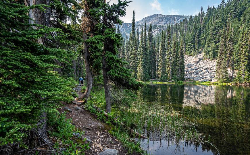
A stop at Marion Lake on the Abbott Ridge Trail
Take the time to visit Marion Lake. It’s a scenic place for a refueling break, especially at the far end of the lake.
According to Parks Canada, the lake – which is more pond like, was named for the daughter of Reverend William Spotwood Green who climbed Mount Bonney back in 1888.
Although we didn’t bother, there is a viewpoint you can visit high above the Trans-Canada Highway where you can watch the trains coming and going into the Connaught tunnel. The tunnel was built to protect the rail cars from Roger Pass avalanches.
Options for a short and long route up Abbott Ridge
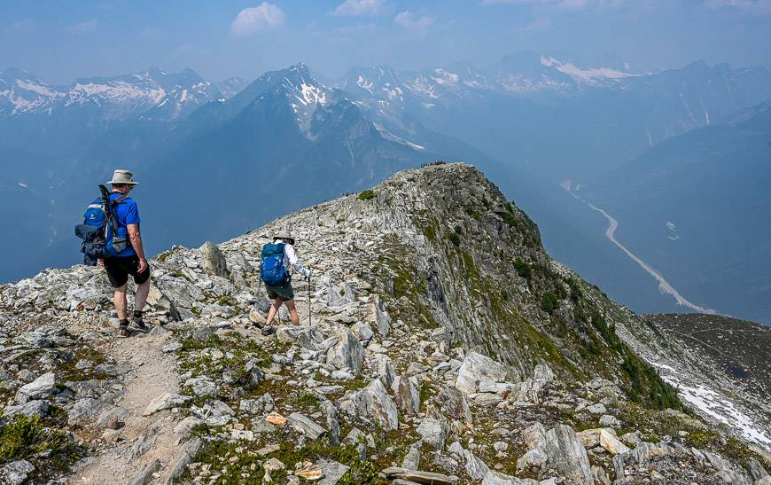
From Marion Lake, it’s a short distance to reach a trail intersection. Go right for the short route up Abbott Ridge and left for the long route.
We did a loop hike – going up via the shortest trail and back via the longer trail. (It adds 2 km to the day.) Just know that in the third week of July there was still one significant snowfield that would be dangerous to cross without an ice axe. We ended up crossing at the top of the snowpack – between the snowfield and the rock.

The Abbott Ridge trail above tree line
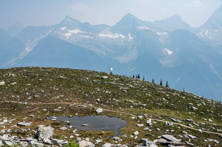
Once you break through the trees, the hiking gets very interesting. The Abbott Ridge trail heads for the ridge on a well trodden trail through boulders and grass. When you reach the pond, you start up switchbacks, eventually going right around the end of Abbott Ridge. The views literally get better with every step.
On the day we did the hike, it was quite smoky but the higher we hiked the windier it got – so visibility improved immensely. It’s a very gradual climb on a good trail around the end of the ridge.
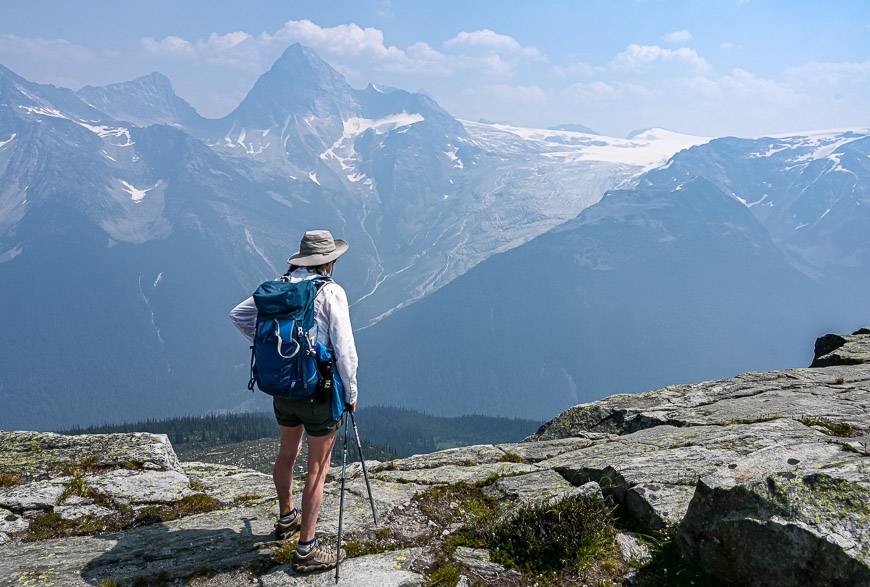
Once on Abbott Ridge you follow it to reach a sign that says – end of trail – except it’s not and the good stuff lies ahead. Just keep following the boot-beaten trail until you reach the final blocks at the end. They require some scrambling – and our guide Alison said you should really be roped up to do it – so we turned back.
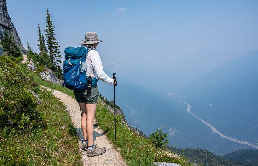
We retraced our steps to the intersection where the short and long loop meet. This time we went right onto the longer route and enjoyed a different landscape than the one we’d hiked up on. The views of Mount Sir Donald were particularly compelling.
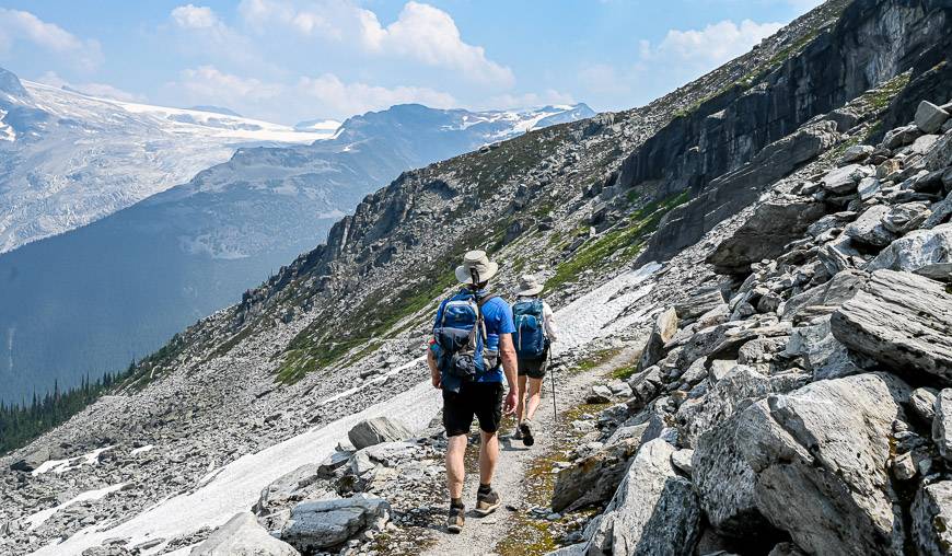
The long route adds a few kilometres to the day but it’s more gradual and a good choice for anyone with knee issues. In July you do have to be prepared for a large snowpack blocking part of the trail. We went over the top and solved the problem. From there it was mellow hiking the rest of the way down.


Map of the trail
Note Abbott Ridge near Marion Lake in the top left quadrant of the map.

Do you need a guide?
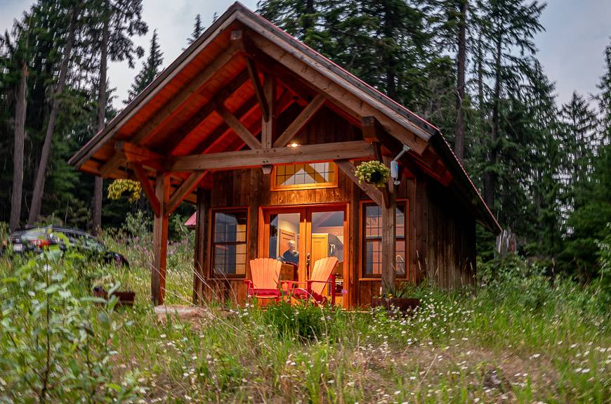
John and I were guests of nearby Heather Mountain Lodge for a couple of nights. They were kind enough to organize a hiking guide so I would understand the services they could offer other guests.
John and I don’t usually need a guide to get around BUT we loved having Alison with us and learning about the area. Alison Dakin is Golden, BC-based and has been guiding most of her adult life. In the winter she is a heli-ski guide at the lodge and in summer she offers her own guiding experiences through her company Gamut Ventures Inc. She can be reached at al@uniserve.com.
For people unfamiliar with the Rockies, or those who are nervous hiking in bear country, a guide is a terrific asset.
They come fully prepared with a massive first aid kit along with a means of getting in touch with a park ranger if anything goes badly wrong. Allison also had maps, hiking poles, bug spray, bear spray, water filters…literally everything you would need. Occasional hikers who don’t necessarily have all the gear would also benefit from her easy manner and expertise.
Finding the Abbott Ridge trailhead
The trailhead for the Abbott Ridge hike is at the end of the road near the Illecillewaet campground, about a kilometre in from the Trans-Canada Highway. The Illecillewaet Campground is well-signed in either direction on the Trans-Canada but it can be a bit tricky to access when you’re driving west, especially the first time you do it.
The Illecillewaet Campground and trailhead is located 3 km west of the summit of Rogers Pass. If you’re driving east, you’ll simply turn right onto the road that takes you to the campground.
But if you’re driving west, you actually drive past the campground about a kilometre to reach a U-turn-Lane. Be sure that you’re in the far-left lane in advance and there is a warning sign that a U-turn-Lane is coming up. Turn left into the U-turn lane and then drive east on the Trans-Canada, getting off when you see the signs to the campground.
What to take on the hike
Water: On a summer day, you’ll go through a lot of water. We refilled water bottles at the pond below the ridge but you’ll need either awater filterorpurification tablets.
Sun hat: Don’t forget awide-brimmed sun hatin summer.
Hiking poles: Consider takinghiking poles– as you’ll find them especially useful for the descent. I prefer the collapsible variety I can put on my pack when not using them.
Food: Take a handful ofenergy barsto keep you fueled on the trail.
Where to stay near the Abbott Ridge trail
You can stay at the Illecillewaet Campground located 3 km west of the summit of Rogers Pass. It’s available on a first come-first served basis. The campground is also the trailhead for a number of hikes into the park including the fabulous Glacier Crest Trail.
Visit Glacier National Park for more information on camping.

Another excellent choice for a basecamp hiking experience is nearby Heather Mountain Lodge. It’s just a 22-minute drive to the east and is immediately off the Trans-Canada Highway. The dining experience is also tops!
A stay in Revelstoke is another option
Revelstoke is also a great place to use as a base for exploring Glacier National Park if you don’t want to camp. There’s plenty to do in Revelstoke in the summer, with hiking in Glacier National Park, just one of many activities.
Top rated picks for accommodation includeBasecamp Resorts Revelstoke, theCourthouse Innif you’re after the B&B experience, andArrows Edge Lodgewith Netflix, a common area for guests, a games and books exchange and more. It is rated superb.
Interested in more hikes and activities??
- 10 Best Yoho National Park Hikes
- A Hike to Eva Lake, Mount Revelstoke National Park, BC
- The Most Unforgettable Walk You’ll Do in Golden, BC
- Things to Do in the Columbia Valley, BC & Nearby
- A Guide to SilverStar in Summer
Click on the photo to bookmark to your Pinterest boards.
